| Download T5688 GPS Track (as .GPX) | |||||||||||||||||||||||||||
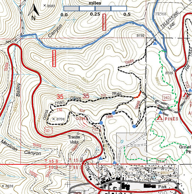
| T10, T568, and T5688 are shown as black dashed lines on the map. | ||||||||||||||||||||||||||||
| LENGTH: 1.0 miles | |||||||||||||||||||||||||||
|
ELEVATION: 8,550-8680 ft 130 ft difference | ||||||||||||||||||||||||||||
| DIFFICULTY: Moderate | ||||||||||||||||||||||||||||
| SCENIC RATING: 2 | ||||||||||||||||||||||||||||
| Download Forest Service Resource | ||||||||||||||||||||||||||||
| Contour Interval: 40 feet Link to map of Cloudcroft Area Link to Full Topo Map | ||||||||||||||||||||||||||||
| ||||||||||||||||||||||||||||
DESCRIPTION: USE: moderate SEASON: April – November. ACCESS: FR = forest road; FS = Forest Service To reach the southern end of T5688, you may start from Cloudcroft or Pines Campground since T5688 makes a junction with T568. To start from the Cloudcroft end of T568, begin in Cloudcroft at the US82 and NM130 highway intersection, and drive one block east along US82. Turn left on Curlew at the Allsups store and drive one block to Burro Avenue. Turn right and drive to the second street going left, signed Mexican Avenue/Osha Trail. Turn left; the road soon splits into Mexican Avenue and Osha Trail Road. Follow the level Osha Trail Road. This route requires access across private land, and that access is currently limited to non-motorized traffic. The signed T5688 trailhead is 0.7 miles from the start of T568, or said another way, about 0.2 miles after the second junction of T568 and T10. To start from the Pines Campground end of T568, locate the T568 trailhead, and hike 0.3 miles along T568. From its junction with T568, T5688 curves northeast along the hill and then bend aback toward the northwest. To reach the northern end of T 5688, begin in Cloudcroft at the US82 and NM130 intersection, and drive US82 east 1.3 miles to the NM244 turnoff on the left. Follow NM244 northwest 0.8 mile to its junction with FR568 on the left. Follow FR568 northwest 0.2 mile to its junction with FR206C; turn left and drive downhill 0.2 mile. A primitive campsite and the beginning of T5688 are on the left DISTANCES AND ALTITUDES: 1.0 miles, altitude gain 130 feet. | ||||||||||||||||||||||||||||
| LOCATION(S) OF ACCESS POINT(S) | ||||||||||||||||||||||||||||
| ||||||||||||||||||||||||||||
| ||||||||||||||||||||||||||||


