T5001D
Accessible Trail
Sacramento Ranger District
|
 |
| Download
T5001D
GPS Track
(as .GPX) | |
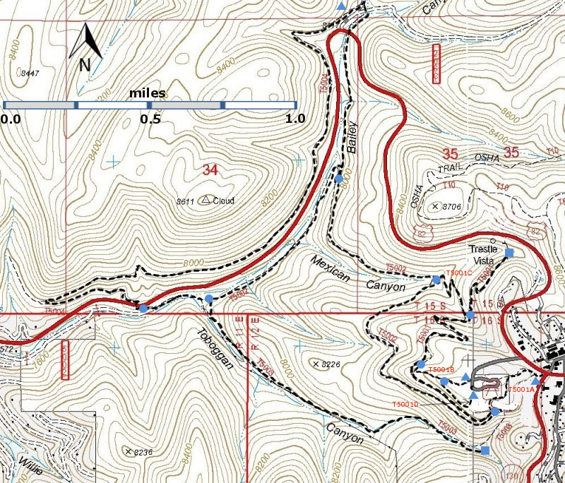
| T5001, T5001A, T5001B, T5001C, T5001D, T5002, T5003, and T5004 are shown as black dashed lines on the map. | | |
| | |
| LENGTH:
0.1 miles
|
|
ELEVATION:
8690 ft,
little
difference |
|
DIFFICULTY:
Easiest
Wheelchair Accessible |
|
SCENIC
RATING:
3 |
|
Download
Forest Service
Resource |
| |
Contour Interval: 40 feet
Link to map of Cloudcroft Area
High Rolls Topo Map Cloudcroft Topo Map | |
| |
| Route Color Codes | paved roads
(red) | | FS roads, open
(blue) | | FS roads, closed or impassable
(magenta) | | | | | main trail(s)
(black dashes) | --- | connector trail(s)
(green dashes) | --- | damaged or intermittent trail(s)
(orange over black dashes) | --- | closed trails(s)
(red over black dashes) | --- | | Symbols | trailhead
(blue triangle) |
 | trail junction
(blue dot) |
 | trail end
(blue square) |
 | | |
| |
| |
| NOTES: Local members of the New Mexico Rails-to-Trails
Association have volunteered many hours of labor to help open these
trails. T5001 follows part of the original Alamogordo and Sacramento
Mountains railroad that connected Alamogordo and Cloudcroft. | |
| |
DESCRIPTION:
The Trestle Recreation Area was opened to the public in 1995 and
contains trails and a picnic area. In 1994, a replica of the exterior
of Cloudcroft's first railroad depot was built here; the site of the
original depot was 100 yards down NM130 from the intersection of NM130
and US82. A volunteer may be on duty during the summer.
T5001D
and the Springer Overlook were developed to allow wheelchair access to
the views that are seen from T5001 and T5002. There are fabulous views
of the canyons and foothills between here and Alamogordo. Beyond lies
the Tularosa Basin, including the White Sands, and the San Andres
Mountains rise on the far side of the basin.
USE: moderate SEASON: April – November.
ACCESS: FR = forest road; FS = Forest Service
To reach the T5001D trailhead and the picnic area, open during summer,
start from the intersection of NM130 and US82 and proceed a few hundred
feet west along US82 to the first paved road on the left. Turn and
drive to the parking and picnic areas at the railroad depot replica.
The East trailhead is one the paved walkway behind the Campground
Host's RV. The west trailhead is a junction with T5001B, near the
overlook.
DISTANCES AND ALTITUDES:
T5001D, 0.1 miles long, is nearly level. | |
| |
| LOCATION(S) OF ACCESS POINT(S) | |
| |
| |
Table | Lat/Lon hddd mm ss.s | UTM/NAD83 | | East Trailhead |
N32 57 25.2
W105 44 58.7 |
13 S
429937
3646771 | | West Trailhead |
N32 57 25.6
W105 45 03.5 | 13 S
429813
3646784 |
| |
| Last Hiked: November 21, 2013 | Web Page Updated:January 26, 2014 | | Copyright Lynn Melton 2014 | Contact: LNFTG14@gmail.com |
| |
| |


