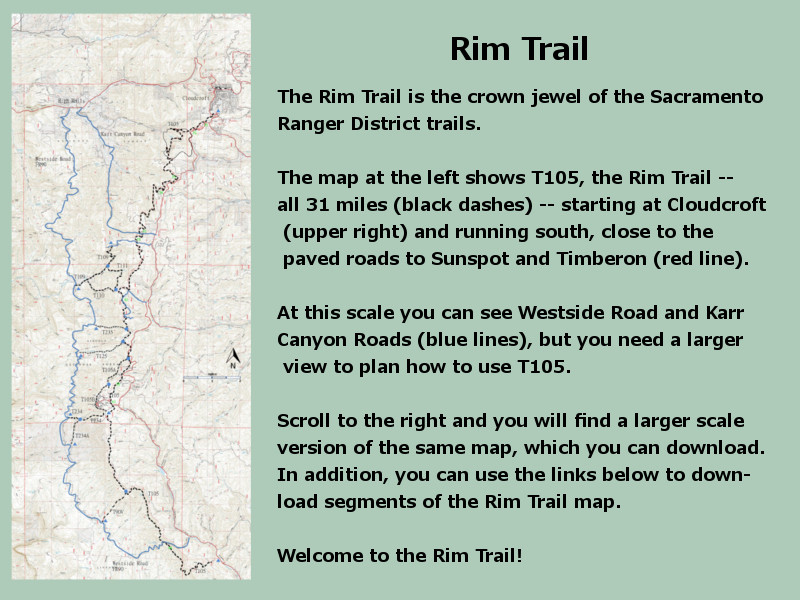
| Download T105 GPS Track (as .GPX) | Rim Trail and Intersecting Trails | ||||||||||||||||||||||||||||||||||||||||||||||||||||||||||||||||||||||||||||||||||||||||||||||||||||||||||||||||||||||||||||||||||||||||||||||||||||||||||||||||||||||||||||||||||||||||||||||||||||||||||||||||||||||||||||
| T105 and trails that intersect it are shown as black dashed lines on the map to the right. | ||||||||||||||||||||||||||||||||||||||||||||||||||||||||||||||||||||||||||||||||||||||||||||||||||||||||||||||||||||||||||||||||||||||||||||||||||||||||||||||||||||||||||||||||||||||||||||||||||||||||||||||||||||||||||||||
 | ||||||||||||||||||||||||||||||||||||||||||||||||||||||||||||||||||||||||||||||||||||||||||||||||||||||||||||||||||||||||||||||||||||||||||||||||||||||||||||||||||||||||||||||||||||||||||||||||||||||||||||||||||||||||||||||
| LENGTH: 30.7 miles See Text | |||||||||||||||||||||||||||||||||||||||||||||||||||||||||||||||||||||||||||||||||||||||||||||||||||||||||||||||||||||||||||||||||||||||||||||||||||||||||||||||||||||||||||||||||||||||||||||||||||||||||||||||||||||||||||||
|
ELEVATION: 8740 - 7620 ft 1120 ft difference | ||||||||||||||||||||||||||||||||||||||||||||||||||||||||||||||||||||||||||||||||||||||||||||||||||||||||||||||||||||||||||||||||||||||||||||||||||||||||||||||||||||||||||||||||||||||||||||||||||||||||||||||||||||||||||||||
| DIFFICULTY: Most Difficult | ||||||||||||||||||||||||||||||||||||||||||||||||||||||||||||||||||||||||||||||||||||||||||||||||||||||||||||||||||||||||||||||||||||||||||||||||||||||||||||||||||||||||||||||||||||||||||||||||||||||||||||||||||||||||||||||
| SCENIC RATING: 3 | ||||||||||||||||||||||||||||||||||||||||||||||||||||||||||||||||||||||||||||||||||||||||||||||||||||||||||||||||||||||||||||||||||||||||||||||||||||||||||||||||||||||||||||||||||||||||||||||||||||||||||||||||||||||||||||||
| Download Forest Service Resource | ||||||||||||||||||||||||||||||||||||||||||||||||||||||||||||||||||||||||||||||||||||||||||||||||||||||||||||||||||||||||||||||||||||||||||||||||||||||||||||||||||||||||||||||||||||||||||||||||||||||||||||||||||||||||||||||
Contour Interval: 40 feet
Rim Trail Map (shown at right) Link to Full Topo Maps (6 maps) | ||||||||||||||||||||||||||||||||||||||||||||||||||||||||||||||||||||||||||||||||||||||||||||||||||||||||||||||||||||||||||||||||||||||||||||||||||||||||||||||||||||||||||||||||||||||||||||||||||||||||||||||||||||||||||||||
| ||||||||||||||||||||||||||||||||||||||||||||||||||||||||||||||||||||||||||||||||||||||||||||||||||||||||||||||||||||||||||||||||||||||||||||||||||||||||||||||||||||||||||||||||||||||||||||||||||||||||||||||||||||||||||||||
INTRODUCTION: DISTANCES:
North Segment; 11.3 miles. Middle Segment; 9.3 miles. South Segment;
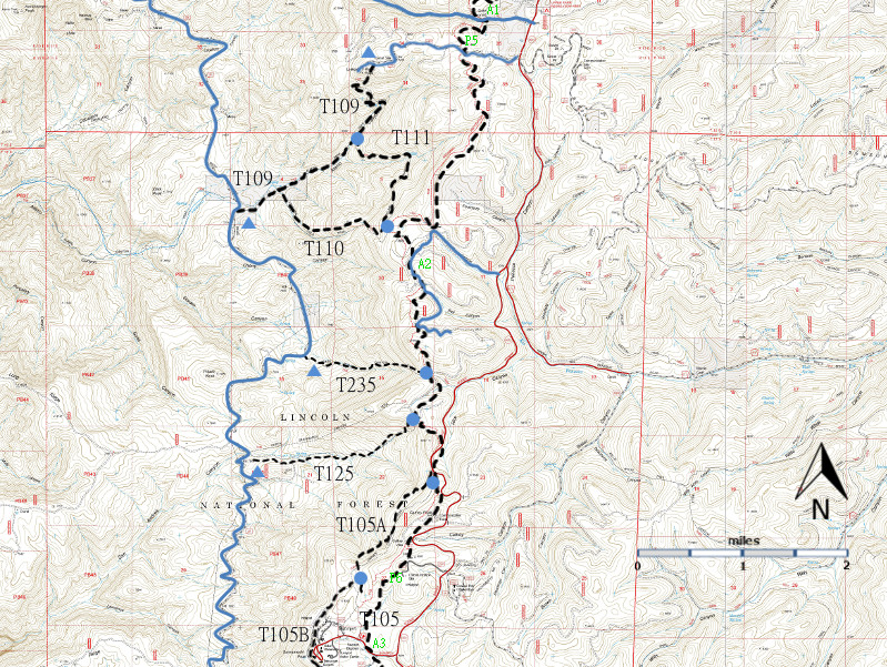
10.4 miles (7.6 miles to Hornbuckle Hill and 2.8 miles further to Sacramento Canyon Road (County C002). USE: North Segment; Moderate (Heavy on Cloudcroft end). Middle Segment; Moderate. South Segment; Low. SEASON: May – November. ACCESS: The GPS coordinates for all twelve access points are given at the end of this web page. North Trailhead: Beginning in Cloudcroft at the New Mexico NM130 and US82 intersection, drive NM130 south 1.2 miles to just beyond the large Deerhead Campground sign. Note the small Sleepy Grass Campground sign on the right just beyond the large sign. Angle left on Sleepy Grass Campground Road, FR24B. Follow the road 50 yards to the parking area at the signed trailhead. This the beginning of the North Segment. For access to the eleven other access points described here, zero your odometer at this point. Rim Trail Parking 1 (P1). Drive NM130 south 0.6 miles to the NM6563 junction. Turn right and follow NM6563 joust 0.1 mile further. There is ample parking on the right. Rim Trail Parking 2 (P2). Continue along NM6563 to mile 1.5. There is ample parking on the right. Rim Trail Parking 3 (P3). This one is a bit tricky. Continue along NM6563 to mile 3.8. The parking area is actually fifty yards up FR636, which turns off to the right, just after one leaves the private property area that contains the old snow sports/tubing facility. There are two paths that lead to T105, one of which begins between the parking area and NM6563. Rim Trail Parking 4 (P4). Continue along NM6563 to mile 4.9. There is ample parking on the right. Access Point 1 (A1). Continue along NM65463 to mile 6.8, and turn right onto Karr Canyon Road. In 0.5 miles T105 crosses Karr Canyon Road. Remember not to count this additional distance as part of the mileage from the North Trailhead. This is the end of the North Segment and the beginning of the Middle Segment. Rim Trail Parking 5 (P5). Continue along NM6563 to mile 7.2, and turn right onto Alamo Peak Road (FR64D). In 0.6 miles, T105 crosses Alamo Peak Road. Parking for 3-4 cars is available. Remember not to count this additional distance as part of the mileage from the North Trailhead. Access Point 2 (A2). Continue along NM6563 to mile 9.6, and turn right onto Atkinson Canyon Road (FR640). The signage is poor for this road, and it may be best to look for a road on the right 0.2 miles after the well-signed Upper Rio Penasco Road turns off of NM 6563 [to Bluff Springs] to the left. Follow (rough) Atkinson Canyon Road 0.8 miles and park near the large berm. To access T105, walk back to FR 640 and hike 0.5 mile up that road to where signed T105 crosses it. To continue south toward Sunspot along T105, turn left and follow the trail up a short incline. To reach the the upper trailheads for T 110 and T 111, turn right and go downhill and across a meadow for 0.5 mile. Remember not to count this additional distance as part of the mileage from the North Trailhead. Rim Trail Parking 6. Continue along NM6563 to
mile 13.5, and turn right into the Cathey Peak Vista area. Ample
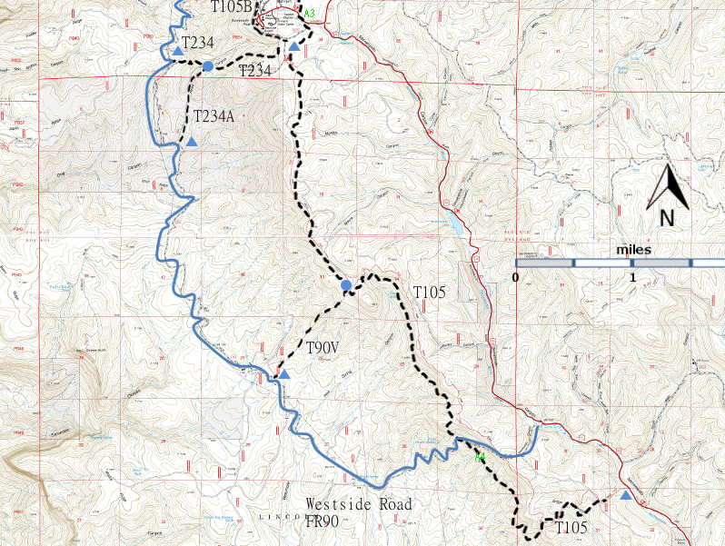
parking is available. Access Point 4 (A4). At the turn off to Sunspot (mile 15.2), leave NM6563 and proceed 6.4 miles along Sacramento Canyon Road (County D002) and turn right onto Westside Road (Same as FR90 and County D003). Follow Westside Road (FR90) 0.8 miles to the top of Hornbuckle Hill and the intersection with T105. South Trailhead. At the turn off to Sunspot (mile 15.2), leave NM6563 and proceed 7.9 miles along Sacramento Canyon Road (County C002), passing en route the junction with FR 460, to the signed trailhead on the right. DESCRIPTION:: As the name Rim Trail implies, the trail generally follows the crest of the Sacramento Mountains from Cloudcroft to beyond Hornbuckle Hill. Along this route you can experience cool summer days and enjoy a variety of forest environments, such as scattered meadows and mountain ridge topography, consisting of many types of landforms, without having to ascend or descend significantly. The North Segment
begins in Cloudcroft, and is a combination of old Indian paths,
homestead trails, roads, and railroad grades, all linked together in
the 1960s and 2000. Trail composition varies from forest litter to
baseball size rocks. Gradients are normally 5% or less, 20% maximum.
This Segment became the first National Forest route in New Mexico to be
designated a National Recreational Trail under the National Trail
System Act of 1968. The path often threads along the upper edges of
deep, timbered canyons. It offers a few good views of the Tularosa
Basin and White Sands 5,000 feet below. However, such distant views are
restricted to less than 10% of trail length, because the forest is
quite dense. The route stays mainly on the west side of the ridge. At mile 3.5 from the beginning of the Middle Segment, the trailheads for T110 and T111 appear. 2.0 mile further, the path crosses a low saddle on the main divide that serves as the upper trailhead for T235. For the next 0.7 mile, between this junction and the trailhead for T125, T105 follows FR640 for 0.7 mile. Just 250 feet after T105 leaves FR640, the upper terminus for T125 is passed. After another 0.8 mile T105 angles left at an old fence corner on the right. Here on the right, T105A begins, paralleling the old fence. In another 0.5 mile, T105 follows FR 5011, Cathey Peak Road, for 0.3 mile to Cathey Canyon Vista parking. After another 1.3 miles, the Middle Segment ends at a T105 sign at Sunspot Highway, within view of the stone entrance sign at Sunspot. The
South Segment includes some features common to both the North and
Middle Segments, in addition to following an impressive hogback for
over a thousand feet. On the whole, this sometimes rocky trail stays
closer to the crest than either of the first two segments. However,
distant views are often highly filtered through forest growth. On the
other hand, excellent views within several hundred feet of the trail
are the rule, due to the terrain and the usual open under story. This
segment also has the longest and steepest climbs and descents (maximum
30%) compared to the other segments. Additional vistas are available by crossing FR90, continuing along T105 to the southeast, following and generally paralleling the rim for another 1.2 miles, where occasional breaks in the forest allow distant views. Unexpectedly, T105 heads down Bridge Canyon, and eventually passes through an area that was severely burned in the 1994 Bridge Canyon Fire. The trail suddenly bears left and heads downhill 0.4 mile, up to 30% gradient, to its terminus at Sacramento River Road (County Road D002). The table below summarizes the information and may help users choose loops. The three columns at the left of the table provide information about distances along T105. The three right columns provide information about distances along the paved roads. The middle column gives the distance between a point of access to T105 and the paved road that one drives. Consider an example of how to use the table: Joe and Sally both love to hike, but they have only one car. They decide to park the car at RTP5 [Find the RTP5 row.]. They hike south along T105 to A2 [Increment = 2.8 miles]. They hate to backtrack, so they decide to hike along Atkinson Field Road to NM6563 [Distance = 1.2 miles]. They turn north on NM6563, hike to Alamo Peak Road [Increment = 2.4 miles], and hike along Alamo Peak Road to their car [Distance = 0.6 miles]. Total distance for the loop is 7.0 miles [2.8 + 1.2 + 2.4 + 0.6]. DISTANCES AND ALTITUDES:
| ||||||||||||||||||||||||||||||||||||||||||||||||||||||||||||||||||||||||||||||||||||||||||||||||||||||||||||||||||||||||||||||||||||||||||||||||||||||||||||||||||||||||||||||||||||||||||||||||||||||||||||||||||||||||||||||
| LOCATION(S) OF ACCESS POINT(S) | ||||||||||||||||||||||||||||||||||||||||||||||||||||||||||||||||||||||||||||||||||||||||||||||||||||||||||||||||||||||||||||||||||||||||||||||||||||||||||||||||||||||||||||||||||||||||||||||||||||||||||||||||||||||||||||||
| ||||||||||||||||||||||||||||||||||||||||||||||||||||||||||||||||||||||||||||||||||||||||||||||||||||||||||||||||||||||||||||||||||||||||||||||||||||||||||||||||||||||||||||||||||||||||||||||||||||||||||||||||||||||||||||||
| ||||||||||||||||||||||||||||||||||||||||||||||||||||||||||||||||||||||||||||||||||||||||||||||||||||||||||||||||||||||||||||||||||||||||||||||||||||||||||||||||||||||||||||||||||||||||||||||||||||||||||||||||||||||||||||||


