| Download T54 GPS Track (as .GPX) | White Mountain Wilderness Trails | ||||||||||||||||||||||||||
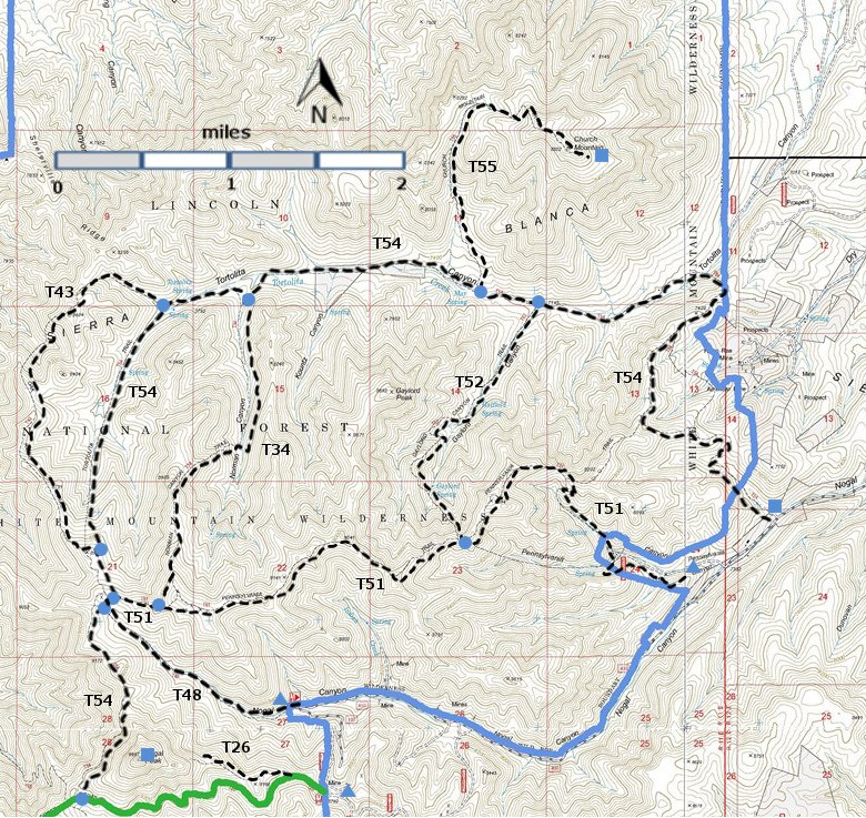
T26, T34, T43, T48, T51, T52, T54, and T55 are shown as labeled black
dashed lines on the
map. The solid blue line is the border of the White Mountain
Wilderness . The solid green line is T25 Crest Trail. | ||||||||||||||||||||||||||||
 | ||||||||||||||||||||||||||||
| LENGTH: 9.1 miles | |||||||||||||||||||||||||||
|
ELEVATION: 7280 - 9160 ft 1880 ft difference | ||||||||||||||||||||||||||||
| DIFFICULTY: Difficult | ||||||||||||||||||||||||||||
| SCENIC RATING: 2 | ||||||||||||||||||||||||||||
| Download Forest Service Resource | ||||||||||||||||||||||||||||
| Contour Interval: 40 feet White Mountain Wilderness Trails (34 MB) Church Mountain Topo Map Nogal Topo Map | ||||||||||||||||||||||||||||
| ||||||||||||||||||||||||||||
SPECIAL NOTE: These primitive trails -- T34, T52, T54, and T55 --are listed because
they provide the only means for experiencing this sizable and fascinating
canyon. T54 is the key to all trails in
Tortolita Canyon. However, its lower end, the only access to the canyon,
crosses private land, and was closed in 1996. It is not known when a practical access to the
lower canyon will be re‑established. Meanwhile, the only realistic way to reach
the trail system is from the upper end of the canyon. See ACCESS below | ||||||||||||||||||||||||||||
DESCRIPTION: T54 is the longest and best of the four
trails. These trails are discussed in order, starting at the upper end of the
main canyon and branching off T54. From the upper end of Tortolita
Canyon, unsigned T34 is the first trail that branches off T54. It goes up Norman Canyon and, although the
lower end threads through partially open understory, it soon passes along a narrow
canyon bottom with considerable growth, and then disappears into impenetrable
thickets. It reappears, passing the
signed end of T51 on the ridge south of Tortolita Canyon, and terminates at
its signed junction with T54.
| ||||||||||||||||||||||||||||
| LOCATION(S) OF ACCESS POINT(S) | ||||||||||||||||||||||||||||
Table
| ||||||||||||||||||||||||||||
| ||||||||||||||||||||||||||||


