| Download T45 GPS Track (as .GPX) | Guadalupe Ranger District Trails | ||||||||||||||||||||||||||
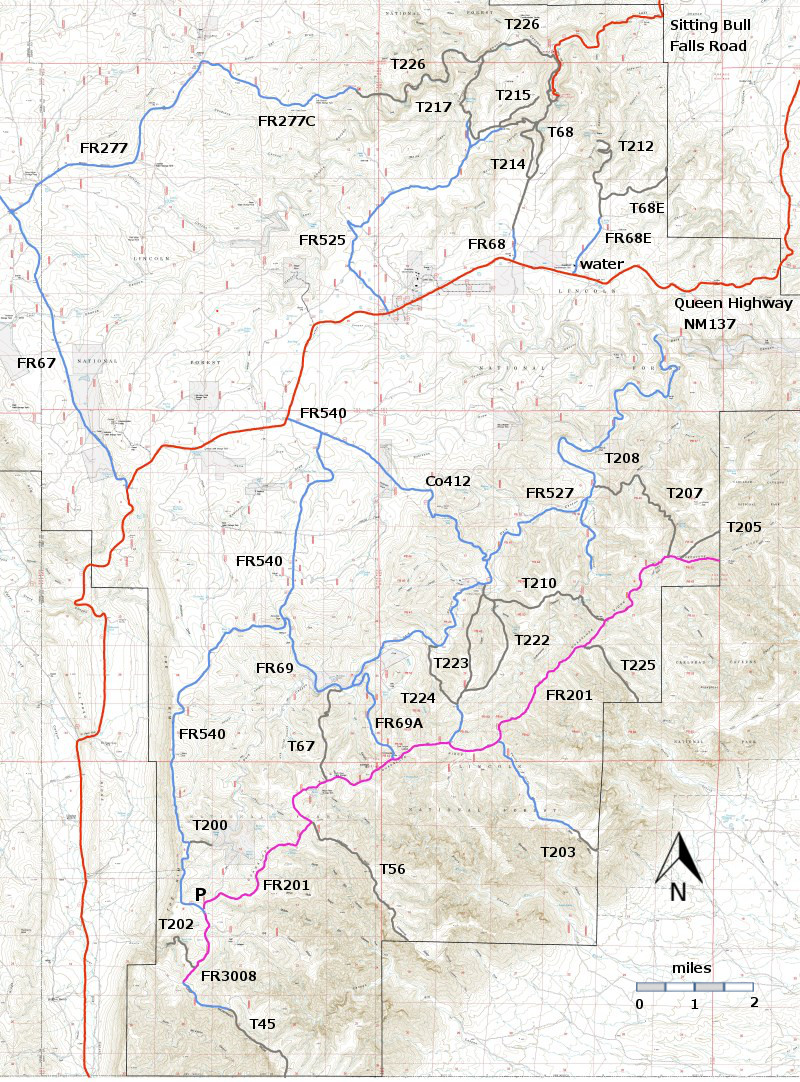
| T45, T56, T200, and T202 are shown as black dashed lines on the map. The portions of FR3008 and FR201 shown in magenta are so bad that they are impassable for most high clearance 4WD vehicles. The large "P" shows the location of an open gravel pad where most hikers will park. In this area there is also a "kiosk" with decent cell phone contact (Verizon, at least) and the GPS coordinates for the site. In case of emergency, you will need to state where you are. | ||||||||||||||||||||||||||||
 | ||||||||||||||||||||||||||||
| LENGTH: 1.8 miles See Text | |||||||||||||||||||||||||||
|
ELEVATION: 6960 - 7340 ft 380 ft difference | ||||||||||||||||||||||||||||
| DIFFICULTY: Moderate | ||||||||||||||||||||||||||||
| SCENIC RATING: 3 | ||||||||||||||||||||||||||||
| Contour Interval: 40 feet Area Topo Map (36 MB) Six Topo Maps | ||||||||||||||||||||||||||||
| ||||||||||||||||||||||||||||
| NOTES: Welcome to the Guadalupe Ranger District and really bad roads. Lovely hikes coupled with difficulty in driving to the starting points of the trails! The segment of FR540 south of the parking area (P) (.0.3 miles) and the segment of FR3008 from its junction with FR540 to the canyon rim (1.2 miles), and all of FR201 are so bad that they are probably impassable for most high clearance 4WD vehicles. In planning hikes that might make use of these roads count the bad road distance as part of the hike rather than part of the “drive to” access. | ||||||||||||||||||||||||||||
DESCRIPTION: Park your vehicle at the parking area P and walk 1.5 miles
along bad roads (segments of FR540 and FR3008).
When you reach the canyon rim, you will be rewarded with wonderful views
into McKittrick Canyon and others. From
this point hike 1.0 miles along a good segment of FR3008 [“Good” doesn’t help
you – you couldn’t get you vehicle to this point!] to the official trailhead for T45. Hike another 1.8 miles and you will reach the
barbed wire fence (and hiker gate) that mark the northern boundary of Guadalupe
National Park. No need to show your park
pass. You may continue on to a
wilderness primitive camping area and to connections with the trail system in
Guadalupe National Park. Now count up the distance.
1.5 + 1.0 + 1.8 = 4.3 miles! This
trail, which is on the books as 1.8 miles long, requires a 4.3 mile hike (one
way). Let’s be fair. That 1.0 mile of (good) FR3008 also has great
views. So you get 2.8 miles of great views. The views are spectacular and the gradients are low. Have a great hike! ACCESS: | ||||||||||||||||||||||||||||
| LOCATION(S) OF ACCESS POINT(S) | ||||||||||||||||||||||||||||
| ||||||||||||||||||||||||||||
| ||||||||||||||||||||||||||||


