| Download T217 GPS Track (as .GPX) | Guadalupe Ranger District Trails | ||||||||||||||||||||||||||
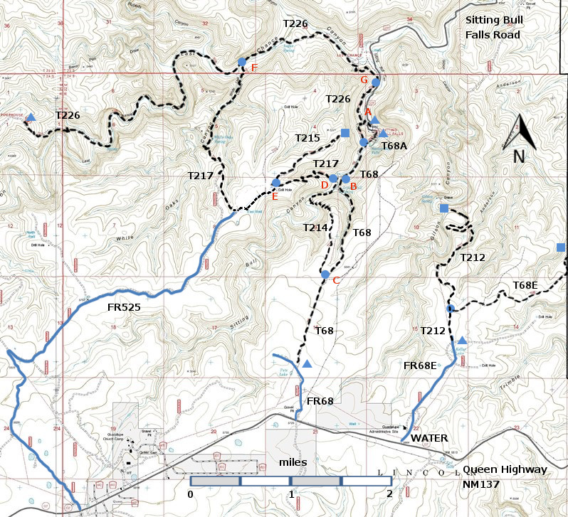
| T68, T68A, T68E, T212, T214, T215, T217, and T226 are shown as black dashed lines on the map below. The trail junctions in the Sitting Bull Falls Area are identified with a letter (A-G), red letters on the map. The photograph at the bottom right shows one such sign. | ||||||||||||||||||||||||||||
 | ||||||||||||||||||||||||||||
| LENGTH: 3.8 miles | |||||||||||||||||||||||||||
|
ELEVATION: 4640 - 5520 ft 880 ft difference | ||||||||||||||||||||||||||||
| DIFFICULTY: More Difficult | ||||||||||||||||||||||||||||
| SCENIC RATING: 3 | ||||||||||||||||||||||||||||
| Contour Interval: 40 feet Area Topo Map (36 MB) Six Topo Maps |
 | |||||||||||||||||||||||||||
|
NOTE: The Sitting Bull Falls Recreation Site, a
beautiful picnic and viewing site, was badly damaged by floods in Fall 2013 and
is closed, by Forest Service order, to public use until further notice. However,
there is a parking area just outside the gate to the Recreation Site, and
hikers should make use of this parking area. | ||||||||||||||||||||||||||||
DESCRIPTION: From its northern end, Junction F with T226 at a perennial stream in Last Chance Canyon, the route soon enters White Oaks Canyon. At 0.6 mile, the trail ascends into a scenic and difficult to access, narrow inner canyon. After another 0.4 mile, the path winds through a fine stand of mature oaks, along with some alligator juniper and madrone. Shortly thereafter, the route passes over a 5-foot high rock wall built by CCC, the highest trail retaining wall known in the Sitting Bull Falls Recreation Site area. T217 soon follows a spur of FR 525 for about 200 feet. After another 0.9 mile, T217 meets T215, Junction E, and then descends via switchbacks into Sitting Bull Canyon. Maximum gradient reaches 25%. Typical semidesert vegetation includes red barked madrone that can be the size of a large shrub or small tree. NOTE: In 2012, a year after the 2011 fire, I hiked up to the stand of oaks in order to see the damage for myself. Much of the canyon walls and tableland have lost their trees. About half the trees in the stand of oaks are dead, but the others can grow and help to restore the area. I still recommend hiking T217. CAUTION: Dead trees become “leaners”, and “leaners” become fallen (or falling!) trees. Be careful. The
elevation at Junction F is 4640 ft, the elevation at the top, not too
far from Junction E, is 5520 ft, and the elevation at Junction D is
4960 ft. | ||||||||||||||||||||||||||||
| LOCATION(S) OF ACCESS POINT(S) | ||||||||||||||||||||||||||||
| ||||||||||||||||||||||||||||
| ||||||||||||||||||||||||||||


