| Download T202 GPS Track (as .GPX) | Guadalupe Ranger District Trail | ||||||||||||||||||||||||||
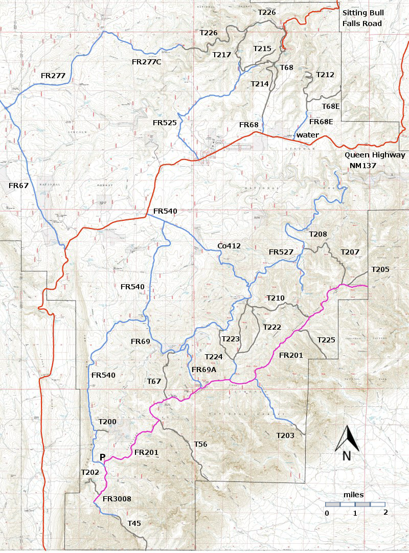
| T45, T56, T200, and T202 are shown as black dashed lines on the map. The portions of FR3008 and FR201 shown in magenta are so bad that they are impassable for most high clearance 4WD vehicles. The large "P" shows the location of an open gravel pad where most hikers will park. In this area there is also a "kiosk" with decent cell phone contact (Verizon, at least) and the GPS coordinates for the site. In case of emergency, you will need to state where you are. | ||||||||||||||||||||||||||||
 | ||||||||||||||||||||||||||||
| LENGTH: 0.9 miles See Text | |||||||||||||||||||||||||||
|
ELEVATION: 6900 - 7340 ft 440 ft difference | ||||||||||||||||||||||||||||
| DIFFICULTY: Difficult | ||||||||||||||||||||||||||||
| SCENIC RATING: 4 | ||||||||||||||||||||||||||||
| Contour Interval: 40 feet Area Topo Map (36 MB) Six Topo Maps | ||||||||||||||||||||||||||||
| ||||||||||||||||||||||||||||
| NOTES: Welcome to the Guadalupe Ranger District and really bad roads. Lovely hikes coupled with difficulty in driving to the starting points of the trails! The segment of FR540 south of the parking area (P) (.0.3 miles) and the segment of FR3008 from its junction with FR540 to the canyon rim (1.2 miles), and all of FR201 are so bad that they are probably impassable for most high clearance 4WD vehicles. In planning hikes that might make use of these roads count the bad road distance as part of the hike rather than part of the “drive to” access. | ||||||||||||||||||||||||||||
DESCRIPTION: T202 takes you into Devil’s Den Canyon and a variety of fine views. It begins on the tableland and descends into the canyon, with shade and a bit of moisture. Along the way you pass an old miner’s cabin and Devil’s Den Spring – not much water, but any water is precious in the Guadalupe RD. The official trail ends, after 0.9 miles, at the canyon bottom. The distance and elevations given at the top of this page are for the official trail. With more work – and more trail finding skills – one can hike another 0.6 miles (and down another 240 feet) to the portal, the forest service boundary, and its spectacular view of the valley to the west of the old reef. The trail toward the portal is intermittent. Stay relatively high on the right side of the stream. [If you were to follow the stream itself, you would end up at the pour-off and would have to backtrack to find a path to the portal. ] Fix your sights on a set of distinctive vertical rocks that define the gateway, the portal, to the spectacular views. Old maps show a trail leading down from the portal, but it leads to private property with no access allowed to NM137. Please return along T202 to the trailhead. The GPS track that you can download for T202 provides a
track all the way to the portal. ACCESS: | ||||||||||||||||||||||||||||
| LOCATION(S) OF ACCESS POINT(S) | ||||||||||||||||||||||||||||
| ||||||||||||||||||||||||||||
| ||||||||||||||||||||||||||||


