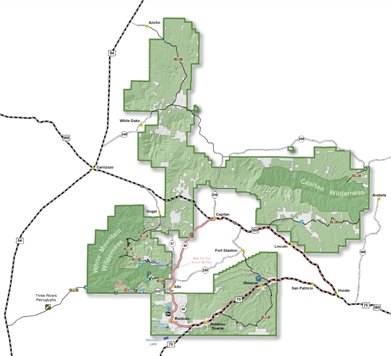
A larger version of this map is available at http://www.fs.usda.gov/main/lincoln/about-forest/districts
General Description
The Smokey Bear Ranger District is named for the iconic bear cub, Smokey Bear, that was found clinging to a tree in a still burning area of Thorium Canyon, now in the Capitan Mountains Wilderness area.
The unusual east-west orientated Capitan Mountains on the northeast side of the Smokey Bear Ranger District, reach an elevation of 10,179 feet. They were formed as a result of molten materials welling up within the earth.
Sierra Blanca Peak is the highest mountain in New Mexico south of the Sangre de Cristo Range in northern New Mexico. Located on Mescalero Apache Reservation northwest of Ruidoso, it rises to 12,003 feet elevation just a mile south of Smokey Bear Ranger District. The entire area is a result of molten magma that pushed up from below. Volcanoes also threw out large quantities of rock and ash.
At lower elevations, Pinyon-Juniper Woodlands dominate. At higher elevations Ponderosa pines occur, and the highest parts of the Smokey Bear Ranger District are Spruce-Fir forest. Cattle graze in the northern potions of the Smokey Bear Ranger District.
In 2004 the Capitan Mountains Wilderness was badly damaged by the massive Peppin fire and subsequent heavy rains, and in 2012 the White Mountain Wilderness was similarly damaged by the massive Little Bear fire and subsequent heavy rains. In both areas many trails are hard to follow, and in the White Mountain Wilderness some trails are closed to the public.
Links to Trails
Listing of Trails by Name
Listing of Trails by Number
Listing of Trails by Location
Updates (most recent first)
Services
Routine services -- gasoline, convenience store, cafe -- are available at Carizozo, Ruidoso, Alto, and Capitan. No services are available at Nogal.
Roads
It is useful to group the trails in the Smokey Bear Ranger District into four areas: Ruidoso, White Mountain Wilderness, Capitan Mountains Wilderness, and Jicarilla/Carrizo (north of US 380 and west of the village of Capitan). The routes to nearly all of the trailheads in the Ruidoso area are paved, and with only modest exceptions, the trailheads can be reached with a standard vehicle. The routes to nearly all the vehicle-accessible trailheads in the White Mountain Wilderness area are paved roads followed by good gravel roads, the most notable exception being T53, Water Canyon, where a high clearance vehicle is required for the last few miles. In the Capitan Wilderness area, only T61 Pierce Canyon Trail on the south side and T64 Capitan Peak Trail on the north side can be routinely reached with a standard vehicle. For all other trails a high clearance vehicle is strongly advised. In the Jicarilla/Carrizo area, about half the trailheads can be reached by good gravel roads. For the other trailheads, the advice ranges from "high clearance vehicle required" through "I couldn't get there." to "Never again.". Pay attention to the access descriptions for each trail.
Maps
In the Smokey Bear RD, users need two maps: the official Forest Service map (latest edition is 2011) and the Motor Vehicle Usage Map. Both maps may be obtained at the Smokey Bear RD office, at the intersection of Mechem and Cedar Creek Drive in Ruidoso. The Forest Service map was $10 when I bought mine. The Motor Vehicle Users Map was free. The latter map is updated every few months, so be sure to obtain (and follow) the latest version.
Users may also purchase specialized maps for the White Mountain Wilderness (2012) and for the Capitan Mountain Wilderness (1992). The White Mountain Wilderness map has a table that provides detailed information about access points to the trails; the Capitan Mountains Wilderness map does not. Neither map provides information about the extent to which fire and torrential rains have damages the trails.
Another map that I have found useful (but not necessary): Ruidoso Area Trail Map is a very well done guide to trails in the Ruidoso Area (including the White Mountain Wilderness and the Fort Stanton area. It is available free at trail kiosks in the Grindstone Lake Area. I got mine at a local merchant, where a $3 donation for trail maintenance was requested. The maps is a collaborative effort of the Forest Service and local hiking and mountain biking groups. It rates some trails by their "biking difficulty" and it includes the distances between trail junctions -- nice for calculating distances for hikes!And one last map: New Mexico Game Management - Unit 37 -(approximately the Smokey Bear District) - Recreation and Game Map. It may be purchased online (paper or electronic version) from BELLGEOGRAPHIC.COM. It shows a lot of old and closed roads. As the author said to me, "Hunters want to know how they can get that elk out".
Lynn Melton is solely responsible for the content of this web page.
Web Page Updated: January 28, 2014
Copyright Lynn Melton 2013
Contact information: LNFTG14@gmail.com