| |
T96 (proposed)
Grindstone Canyon Trail
Smokey Bear Ranger District
|
 |
| Download
T96
GPS Track
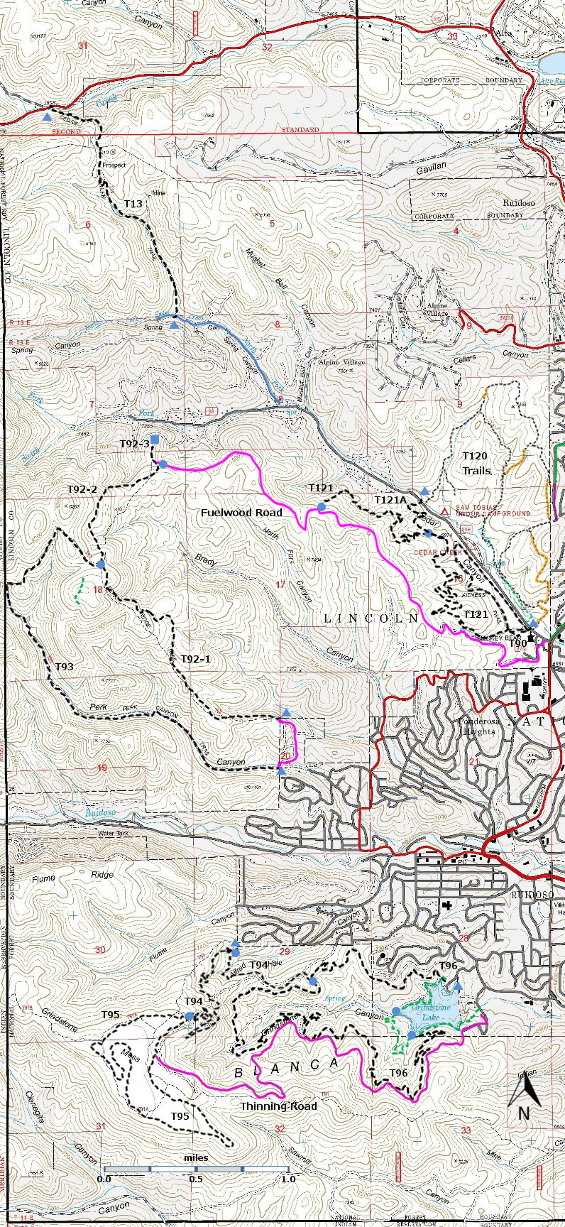
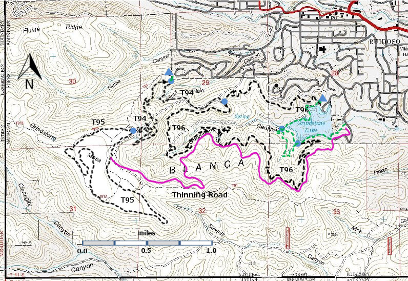
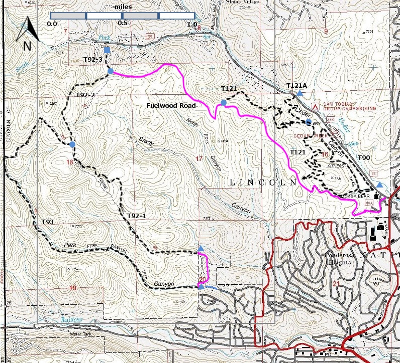
(as .GPX) | Ruidoso Area Trails | | T94, T95, and T96 are shown as black dashes on the map. | | | | |
 | | LENGTH:
5.4 miles
See Text | |
ELEVATION:
6850 - 7200 ft
350 ft
difference | | DIFFICULTY:
More Difficult | | SCENIC
RATING:
2 | | | | | Contour Interval: 40 feet
Ruidoso Area Map
Full Topo Map | | | | | Route Color Codes | paved roads
(red) | | FS roads, open
(blue) | | FS roads, closed or impassable
(magenta) | | | | | main trail(s)
(black dashes) | --- | connector trail(s)
(green dashes) | --- | damaged or intermittent trail(s)
(orange over black dashes) | --- | closed trails(s)
(red over black dashes) | --- | | Symbols | trailhead
(blue triangle) |
 | trail junction
(blue dot) |
 | trail end
(blue square) |
 | | |
| | | | NOTE: The Trail Guide: Lincoln
National Forest (2002 edition) describes three trails in the Grindstone Mesa area,
T91, T91A, and T91B. These trails were
based on old logging roads. When the new
trails were developed, with the intent to provide good trails for mountain
biking, these new single path trails were built with little use of the old logging
roads. In effect, the old trails were
abandoned and new trails were built. At
the time I hiked these trails (Fall 2013), the signage was not in place, but
there was rarely any ambiguity about how to proceed when a new trail crossed a
road. Good Show!
The three trails, T94 Alfred Hale Connector Trail, T95 Grindstone Mesa
Loop Trail, and T96 Grindstone Canyon Trail, were developed by the Forest
Service, the City of Ruidoso, the Ruidoso Chapter of Ecoservants, and the
Ruidoso area mountain biking community.
They, and the Fisherman’s Trail, provide access to the beauty of
Grindstone Lake and Grindstone Mesa.
Grindstone Lake is just outside the Lincoln National Forest
boundary. The green dashed line –
Fisherman’s Trail – provides a low gradient loop around Grindstone Lake. T96 Grindstone Canyon Loop Trail also makes a
loop (using some of Fisherman’s Trail) but at higher elevation, and with more
forest and better views. T94 Alfred Hale
Connector Trail begins in Alfred Hale Canyon and ascends through multiple
switchbacks to the gem, T95 Grindstone Mesa Trail, which meanders, will little
change in elevation, through the beautiful Ponderosa forest on the top of
Grindstone Mesa.
In the past few years, the forest in the Grindstone Mesa area has been
thinned in order to reduce the fire danger.
This effort has now ended. In
order to move machinery into the areas to be thinned, a new road was built on Forest
land. It has no number and is closed to
motorized vehicles. It is shown in magenta
on the map and is labeled “Thinning Road”.
Hikers, bikers, and horses can use this road for additional access to the
area. | | | | DESCRIPTION:
Watch out for mountain bike folks! (who are well-mannered but come upon
you quickly). This is a popular trail
around Grindstone Lake. It provides more
challenge and greater access to views of Grindstone Lake and the surrounding
area. Designed and laid out by mountain bikers, it makes a large low gradient
loop around the southwestern part of Grindstone Lake, and makes use of
switchbacks at its eastern end to keep the gradients manageable.
ACCESS:
The unsigned trailhead for T96 is located at the primary access to
Grindstone Lake, west of the dam, just to the left of the hiker kiosk. There are multiple ways to reach Grindstone
Lake, particularly if you are familiar with Ruidoso. The paragraph below describes one way.
In Ruidoso, go
1.3 miles south from Smokey Bear Ranger District Office along Mechem Drive (NM48)
to where it turns left at a traffic light. This is the intersection of Mechem
and Sudderth Drive. Turn right and head
west on Sudderth. At mile 0.2 from the
traffic light, turn left at a complicated intersection onto Resort Drive. Follow the twists and turns of Resort Drive
0.7 miles to the well-signed entrance to the Grindstone Lake recreation area.
In order to
reach access points at the east end of Grindstone Lake (below the dam),
continue 0.2 miles further on Resort Drive, past the dam, to a small recreation area on the south side
of the road [Starting point for the Frisbee Golf Course]. The east end of T96 may reached from this
area. Hike to the south side of the
dam. You may hike up the Thinning Road
or scramble up to the south end of the dam and find an unsigned connector
trail. Follow it 0.5 miles to the unsigned
junction with T95, which joins this connector at a low angle. You will need to make nearly a 180 degree
left turn to get onto T95.
T96 may also
be accessed via T94 Alfred Hale Connector Trail. Drive to the mid-point access for T94 off
Westminster Drive, and hike 0.9 miles down T94 to its unsigned junction with
T96.
DISTANCES AND ALTITUDES: Starting
from the Grindstone Lake Trailhead, T96 ascends 360 ft in 2.3 miles (3%
gradient), descends 260 ft in the next 0.8 miles (6%
gradient), ascends 100 feet in the next 1.5 miles (1.3%
gradient), and
then descends 160 feet in the last 0.8 miles (4.4 % gradient). | | | | | LOCATION(S) OF ACCESS POINT(S) | | | | | | | Lat/Lon hddd mm ss.s | UTM/NAD83 | | Trailhead -Grindstone Lake | N33 19 26.7
W105 41 05.4 | 13 S
436260
3687424 | | T94/T96 Junction | N33 19 25.5
W105 41 50.0 | 13 S
435106
3687395 | | T96/Connector Junction | N33 19 11.0
W105 41 16.8 | 13 S
435962
3686943 |
| | | Last Hiked: October 27, 2013 | Web Page Updated:January 31, 2014 | | Copyright Lynn Melton 2014 | Contact: LNFTG14@gmail.com |
| | | |
|