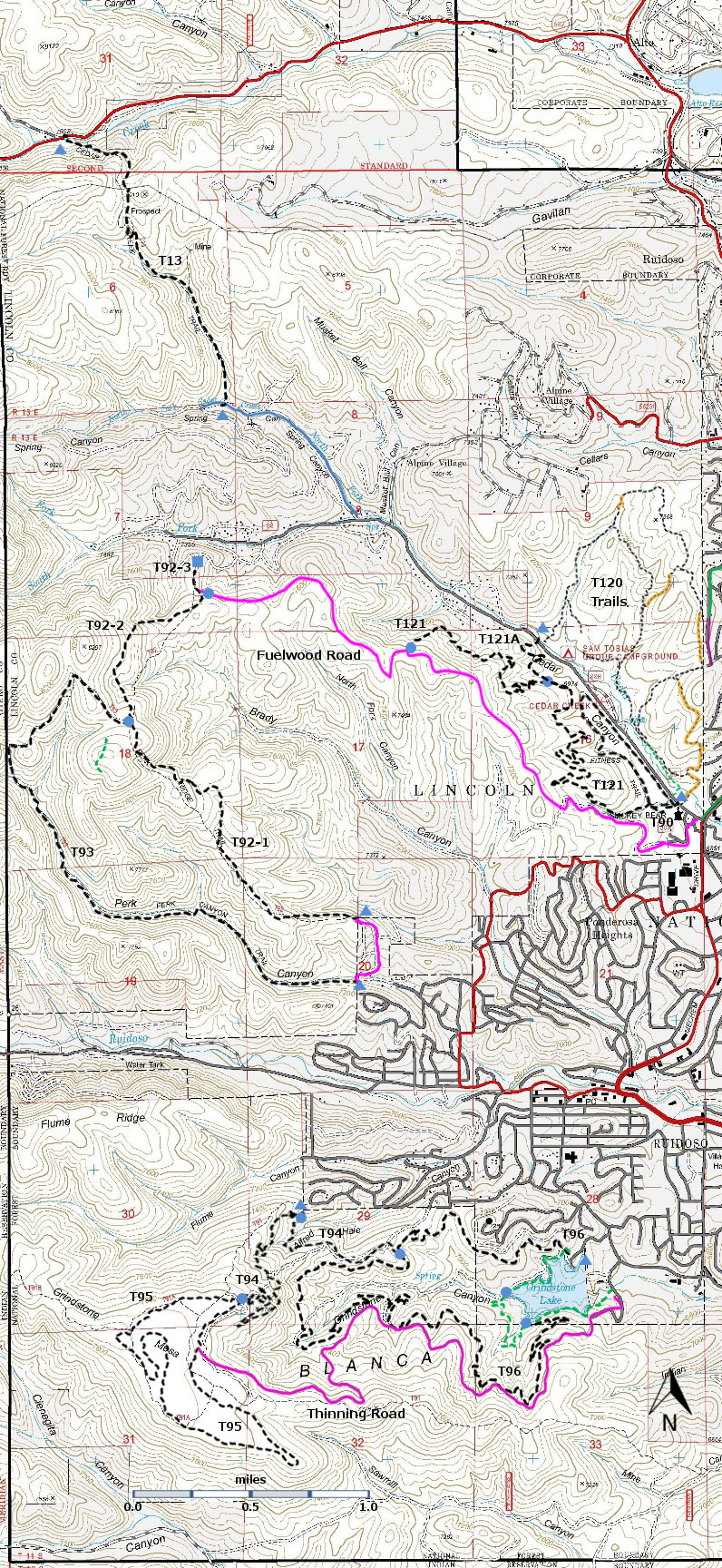
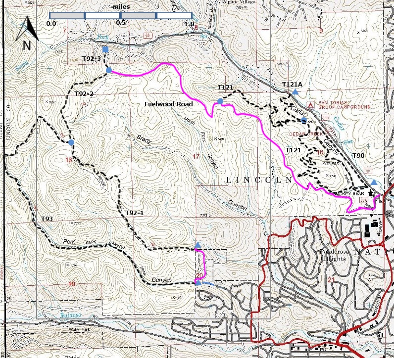
NOTE: The Trail Guide: Lincoln
National Forest (2002 edition) describes three trails in the Grindstone Mesa area,
T91, T91A, and T91B. These trails were
based on old logging roads. When the new
trails were developed, with the intent to provide good trails for mountain
biking, these new single path trails were built with little use of the old logging
roads. In effect, the old trails were
abandoned and new trails were built. At
the time I hiked these trails (Fall 2013), the signage was not in place, but
there was rarely any ambiguity about how to proceed when a new trail crossed a
road. Good Show!
The three trails, T94 Alfred Hale Connector Trail, T95 Grindstone Mesa
Loop Trail, and T96 Grindstone Canyon Trail, were developed by the Forest
Service, the City of Ruidoso, the Ruidoso Chapter of Ecoservants, and the
Ruidoso area mountain biking community.
They, and the Fisherman’s Trail, provide access to the beauty of
Grindstone Lake and Grindstone Mesa.
Grindstone Lake is just outside the Lincoln National Forest
boundary. The green dashed line –
Fisherman’s Trail – provides a low gradient loop around Grindstone Lake. T96 Grindstone Canyon Loop Trail also makes a
loop (using some of Fisherman’s Trail) but at higher elevation, and with more
forest and better views. T94 Alfred Hale
Connector Trail begins in Alfred Hale Canyon and ascends through multiple
switchbacks to the gem, T95 Grindstone Mesa Trail, which meanders, will little
change in elevation, through the beautiful Ponderosa forest on the top of
Grindstone Mesa.
In the past few years, the forest in the Grindstone Mesa area has been
thinned in order to reduce the fire danger.
This effort has now ended. In
order to move machinery into the areas to be thinned, a new road was built on Forest
land. It has no number and is closed to
motorized vehicles. It is shown in magenta
on the map and is labeled “Thinning Road”.
Hikers, bikers, and horses can use this road for additional access to the
area. | |
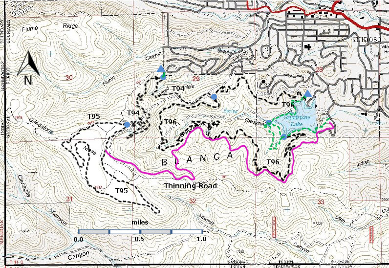
DESCRIPTION:
This is what a
forest trail should be! In the 3.4 mile
Grindstone Mesa loop, the elevation varies by barely 100 feet, and in many
areas there are stand of large Ponderosa pines with an open understory. I measured one old Ponderosa at 3’8” in
diameter. Many thanks to the mountain
bikers and others who helped to design, lay out, and construct T95.
There are many
old roads in this area, but the newer T95 was easy to hike. When it crosses a road, the single path T95
is usually visible just across the road, and sometime there are cairns. Easy hiking, and when the signage is put in
place, really fine hiking.
ACCESS:
You cannot
drive to T95 Grindstone Mesa Trail. You
can park at the east side of the Grindstone Lake dam, and hike/bike/horse 3.5
miles up the Thinning Road to T95, elevation gain 1030 feet. However, you may prefer to make use of the
upper portion of T94 Alfred Hale Connector Trail, which can be accessed from
Westminster Drive. Either access will
provide very nice views of the Grindstone Lake area and beyond.
Access by
Thinning Road:
In Ruidoso, go
1.3 miles south from Smokey Bear Ranger District Office along Mechem Drive (NM48)
to where it turns left at a traffic light. This is the intersection of Mechem
and Sudderth Drive. Turn right and head
west on Sudderth. At mile 0.2 from the
traffic light, turn left at a complicated intersection onto Resort Drive. Follow the twists and turns of Resort Drive
0.9 miles to the small recreation area on the south side of the road [Starting
point for the Frisbee Golf Course]. Hike to the south side of the dam, where the
Thinning Road (unsigned) starts. It may
be a bit tricky to find unsigned T95, but remember that it is a single path
trail, and where it crosses the roads there are often cairns to guide the eye.
Access by T94:
In Ruidoso go
1.3 miles south from Smokey Bear Ranger District Office along Mechem Drive (NM48)
to where it turns left at a traffic light. This is the intersection of Mechem
and Sudderth Drive. Zero your trip
odometer here. Turn right and head west on Sudderth. At mile 0.2 from the traffic light, turn
right at a complicated intersection on unsigned Main Road, within sight of a 1st
National Bank office. At mile 0.5, proceed straight ahead on Flume Canyon
Drive. At mile 0.7, angle slightly left and continue following Flume Canyon
Drive.
At mile 0.8,
enter the Black Forest subdivision. Just
beyond the imposing entrance to the subdivision, angle slightly right and
follow pavement uphill. At mile 1.4, turn left on signed King Richard Drive, a
steep, graveled road. At mile 1.8, turn
right on Westbury Drive. At mile 2.0, turn left on Westminster Road and follow
for 0.2 mile, 100 feet beyond the top of the hill, to an unpaved (and
potentially muddy) saddle, just beyond Lancelot Court. Park here.
It is tempting to hike up the old road beyond the closed Forest Service
gate. However the unsigned single path access
to T94 begins just to the left of the gate.
The unsigned junction with T94 is about 100 feet down this trail. Continuing straight leads downhill (0.9
miles) to a junction with T96. Turning
right leads uphill (1.8 miles, elevation gain 480 feet), through multiple
switchbacks to a junction with T95 at its eastern end (unsigned but this is a junction
with a wide, well-maintained trail.)
DISTANCE AND ALTITUDE:
If one accesses T95 by T94 (Westminster Road), there is a 1.8 mile hike
to reach T95, a 3.4 mile loop around T95, and a 1.8 mile hike back to the car,
for a total of 7.0 miles. The elevation
gain (and decrease) is 580 feet – 480 feet to reach T95 and 100 feet gain (and decrease)
in going around T95. | |


