| Download T92 GPS Track (as .GPX) | Ruidoso Area Trails | ||||||||||||||||||||||||||
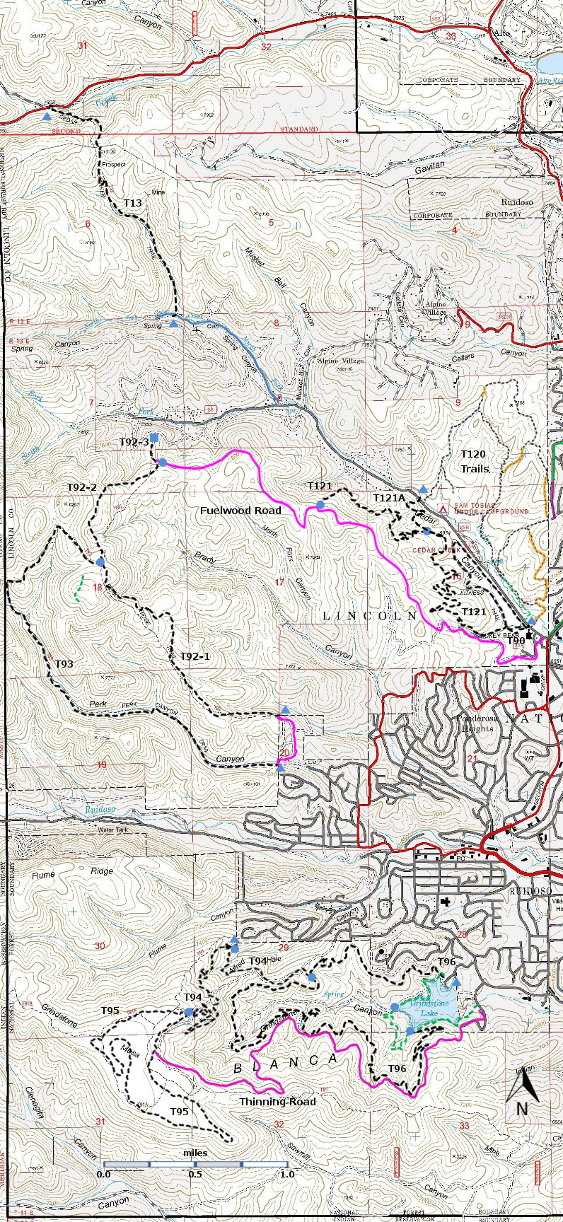
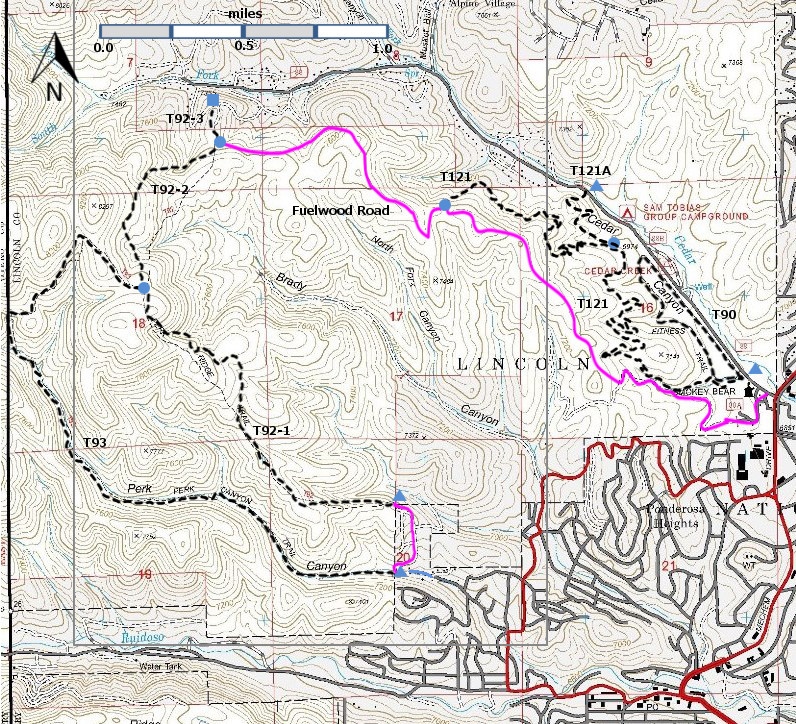
| T90, T92, T93, T121, and T121A are shown as black dashed lines on the map. There is no access across private land to Cedar Creek Road. | ||||||||||||||||||||||||||||
 | ||||||||||||||||||||||||||||
| LENGTH: 2.6 miles See Text | |||||||||||||||||||||||||||
|
ELEVATION: 7040-7580 ft 540 ft difference | ||||||||||||||||||||||||||||
| DIFFICULTY: More difficult | ||||||||||||||||||||||||||||
| SCENIC RATING: 2 | ||||||||||||||||||||||||||||
| Download Forest Service Resource | ||||||||||||||||||||||||||||
| Contour Interval: 40 feet Ruidoso Area Map Full Topo Map | ||||||||||||||||||||||||||||
| ||||||||||||||||||||||||||||
|
DESCRIPTION: From its southeastern trailhead, T92
initially follows an old road along the ridge.
At mile 0.8 from the Forest boundary, a 3-ft high cairn marks the shift
from the old road to a foot path leading to the right. The trail threads through a mostly mixed
conifer and oak corridor to the trail's high point at mile 1.7 from the lower
trailhead, close to the junction with trail T93. The route descends through an
abundant stand of young white fir to the picturesque head of a small canyon at
mile 2.0. The trail reaches its northern terminus at large, privately owned
water tanks. Maximum gradients vary from 25% to
50% between the southeastern trailhead and the high point; commonly up to 30%
for the remainder of the trail. Trail condition ranges from poor to excellent.
It passes through scattered open areas and small meadows. Distant vistas are
sparse and usually filtered. The best view is at mile1.8, if one ventures to
the east about 300 feet to the edge of a cliff for a 100 degree vista that
includes East Mountain in the Capitans, and much of forest-obscured Ruidoso. USE: Moderate SEASON:
Year-round, depending on the weather. ACCESS: FR =
forest road; FS = Forest Service The upper trail end cannot be
reached by car; no access is allowed across private land. It can be accessed on
foot. From the Smokey Bear Ranger Distinct office in Ruidoso, hike along
Fuelwood Road (immediately behind the building), 3.2 miles (altitude gain = 700
feet) to the poorly signed junction with T92-2 (see Distances and Altitudes
section below) To access the lower trailhead, in
Ruidoso, go 1.3 miles south from Smokey Bear Ranger District Office along New
Mexico NM48 to where it turns left at a traffic light. This is the intersection
of Mechem and Sudderth Drive. Zero your trip odometer here. Turn right
and head west on Sudderth. At mile 0.2 from the traffic light, turn right at a
complicated intersection on unsigned Main Road, within view of a 1st National
Bank office. At mile 0.5, continue following Main Road as it angles right. At
mile 0.7, at the Story Book Cabins sign, turn right on signed, paved Ebarb
Drive. At mile 1.0, turn left on signed paved Perk Canyon Drive. At mile 1.5,
the road and pavement ends, and there is modest parking and the carsonite sign
for T93 (not this trail). It is recommended that hikers park here and hike 0.4
miles up (badly eroded) Thunderbird Lane to the signed T92 trailhead, which is
located at the Forest boundary. In order to drive up Thunderbird Lane, an
unmaintained dirt road, to the T92 trailhead, a 4 wheel drive high-clearance
vehicle is strongly recommended. There is a carsonite T92 sign at the gate where T92
starts. DISTANCES AND ALTITUDES: Hikers should think of T92 as
having three segments, T92-1, T92-2, and T92-3. [These are not official Forest
Service designations, but they are useful in thinking about how to plan hikes.] T92-1 (1.7 miles) starts at the
Forest boundary on the southeast and ends at its signed junction with T93. Starting at T93 (3.0 miles) and returning to
the lower T93 trailhead by T92-1 (1.7 miles) and Thunderbird Drive (0.4 miles)
make a nice 5.1 mile loop hike. T92-2 starts at the junction of
T92-1 and T93 and ends at its poorly-signed junction with Fuelwood Road. A hike along Thunderbird Road (0.4 miles), T92-1
(1.7 miles), T92-2 (0.8 miles), and Fuelwood Road (3.2 miles) is 6.1 miles. This hike ends at the Forest Service
headquarters at Mechem and Cedar Creek Road. T92-3 starts at the junction of
T92-1 and Fuelwood Road and ends at the large, privately owned water
tanks. This 0.1 mile long segment is a
vestige of the earlier trail alignment in which there was access across private
land to Cedar Creek Road. Advice: Skip
it. The one way distance for T92 itself is 2.6
miles, with a net altitude change of 270 feet. However, hikers will probably
make more use of the following data: Thunderbird Drive, 0.4 miles,
ascends 220 feet, not passable for normal vehicles; | ||||||||||||||||||||||||||||
| LOCATION(S) OF ACCESS POINT(S) | ||||||||||||||||||||||||||||
| ||||||||||||||||||||||||||||
| ||||||||||||||||||||||||||||


