T78
Lookout Mountain Trail


Smokey Bear Ranger District
TL-green-190.jpg
Download
T78
GPS Track
(as .GPX)
White Mountain Wilderness Trails
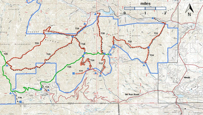
T12, T15, T16, T18, T19, T20, T20, T24, T77, and T78 are shown as black dashed lines on the map.
 The solid blue line is the border of the White Mountain Wilderness.  The solid green line is
T25 Crest Trail.  The red over black dashes indicates that the trail is badly damaged and has
been closed to the public by Forest Service order.
T78 is outside the White Mountain Wilderness Area. WMW6c2mnr11.jpg

WMW6c2m-p1r-RTS.jpg

LENGTH:
0.8 miles
See Text
ELEVATION:
11220 - 11520 ft
300 ft

difference
DIFFICULTY:
Difficult
SCENIC
RATING:
4
Contour Interval: 40 feet
White Mountain Wilderness Trails (34 MB)

Full Topo Map
Route Color Codespaved roads
(red)
FS roads, open
(blue)
FS roads, closed or impassable
(magenta)
main trail(s)
(black dashes)
---connector trail(s)
(green dashes)
---damaged or intermittent trail(s)
(orange over black dashes)
---closed trails(s)
(red over black dashes)
---
Symbolstrailhead
(blue triangle)
blue-triangle.jpgtrail junction
(blue dot)
blue-dot.jpgtrail end
(blue square)
blue-square.jpg
SPECIAL NOTE:  All land south of the crest of Lookout Mountain is on Mescalero Apache Reservation and belongs to that tribe. This includes Sierra Blanca Peak.  Currently (early 2002), hikers are permitted to access Sierra Blanca provided they register at the Tribal Office.  Call (505) 464-4494 for latest information, particularly to learn whether this extraordinary opportunity remains available.

DESCRIPTION:

T78 leads from T25 to the summit of Lookout Mountain, the highest point on Lincoln National Forest!  Shortly after T78 begins, it passes signed Ice Spring. For 0.3 mile, it is an easy grade and threads through a beautiful corridor of tall, mixed conifers just prior to entering the Ski Apache Ski Area. For the next 0.3 mile, the grade increases to 30%, ascending progressively steeper meadows where the route becomes somewhat vague. After passing the west side of Gazebo Snack Bar (operates only during the ski season), the trail angles up a very steep and rocky path for the last 0.2 mile to a constructed viewing area in disrepair on the summit of Lookout Mountain. This last section of path is above tree line and traverses tundra!  [Portions of the Ski Apache area were  burned in the 2012 Little  Bear Fire; the route may pass through burned out forest, particularly along T25 between T15 and T78.]

From the top of Lookout Mountain is a splendid 360-degree vista, including an impressive view of Sierra Blanca Peak, the highest point in southern New Mexico. This peak, at over 12,000 feet, can also be seen from Emory Pass in Gila National Forest, 120 miles to the SW, on clear afternoons when snow covers the mountain.  Sierra Blanca also overlooks the famous White Sands area, part of which is 8,100 feet lower in elevation than the peak. This is the greatest elevation difference found along line of sight anywhere within New Mexico or Arizona!

 ACCESS:

 
To reach T78, take T15 from a small parking area at the Ski Apache Ski Area entrance gate for 0.6 mile, to where it ends on T25, Crest Trail. Turn left and hike T25  2.0 miles to its junction with T78.  At this point, continue straight ahead and the trail becomes T78. (T25 turns right.)  To reach the small parking area, see the write-up for T15.  The result is that one hikes 2.6 miles to reach the 0.8 mile long T78.

LOCATION(S) OF ACCESS POINT(S)
Lat/Lon hddd mm ss.sUTM/NAD83
Junction of T78 and T25N33 23 56.3
W105 49 05.9
13 S
423903
3695817
Trail End
(Lookout Mountain)
 N33 23 27.5
W105 48 42.6
13 S
424498
3694926

Last Hiked:  2001Web Page Updated:February 21, 2014
Copyright Lynn Melton 2014Contact: LNFTG14@gmail.com