T64
Capitan Peak Trail


Smokey Bear Ranger District
TL-green-190.jpg 
Download
T64
GPS Track
(as .GPX)
Capitan Mountains Trails
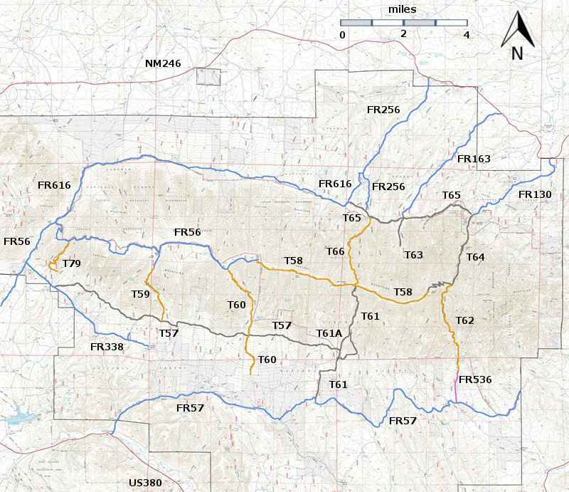
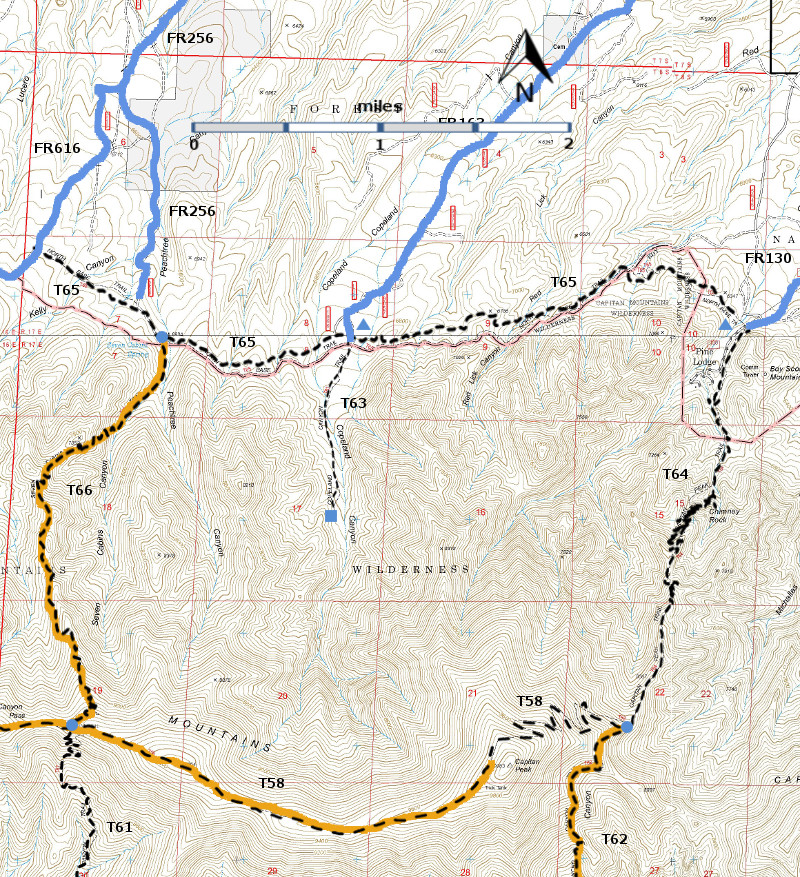
T58 (partial),T61 (partial), T62 (partial), T63, T64,  T65, and T66 are shown as black dashed lines on the map. As part of the Capitan Mountains Wilderness Area trail system, these trails allow only hiking and pack animal activities.
Capitan-mc-RTS-r8p5.jpg

Capitan-mc-RTS-cb5a-rf.jpg

LENGTH:
5.6 miles
ELEVATION:
6300 - 8600 ft
2300 ft

difference
DIFFICULTY:
More Difficult
SCENIC
RATING:
4
Contour Interval: 40 feet
Capitan Mountains Area  (37 MB)

Arabela Topo Map   Capitan Peak Topo Map
Route Color Codespaved roads
(red)
FS roads, open
(blue)
FS roads, closed or impassable
(magenta)
main trail(s)
(black dashes)
---connector trail(s)
(green dashes)
---damaged or intermittent trail(s)
(orange over black dashes)
---closed trails(s)
(red over black dashes)
---
Symbolstrailhead
(blue triangle)
blue-triangle.jpgtrail junction
(blue dot)
blue-dot.jpgtrail end
(blue square)
blue-square.jpg

 DESCRIPTION:

 With more than 60 switchbacks, T64 provides the easiest gradient (under 15%) of all trails that ascend or descend the Capitan Mountains. With rare exception, T64 is easy to discern. At times it follows ridges and borders the edge of high cliffs, providing spectacular deep canyon and distant views. The most impressive view of Chimney Rock is just prior to sunset, through breaks in trees, at about mile 3.1 from its lower end, although it is signed at mile 1.8.  These are the best vistas along any trail in the Capitan Mountains, except for T66, Seven Cabins Trail.

To reach Capitan Peak, hike 1.6 miles west along T58, Summit Trail, beyond the common T64/T58/T62 junction.  Near a wooden sign giving direction to Capitan Peak, leave T58 and hike south 0.2 mile over rough ascending terrain, gaining about 200 feet in elevation. The resulting panoramic view is worth the effort!  The change in elevation from the T64/T58/T62 junction to the peak is about 1480 feet.

 ACCESS:

 For those driving passenger cars, T64 has the most accessible trailhead to the Capitan Mountains Wilderness, if FR130 was graded after the last storm.

 To reach the lower trailhead, start in Capitan from the US380 and New Mexico NM246 intersection. Drive paved NM246 north and east 32 miles to milepost 32.  After another 0.2 mile, turn right on signed Boy Scout Mountain Road, also signed FR130.  Follow the sometimes rough dirt road, angling slightly right at a confusing intersection after 3.5 miles.  The signed T64 trail is 0.3 miles further on the left.  To reach the upper trailhead, one must approach it from T58 or from T62.  
LOCATION(S) OF ACCESS POINT(S)
Lat/Lon hddd mm ss.sUTM/NAD83
Trailhead (North, Lower) N33 37 35.6
W105 14 31.6
13 S
477544
3720777
Junction of T58 and T64 N33 35 39.1
W105 15 14.2
 13 S
476438
3717191

Last Hiked:  2001Web Page Updated:February 21, 2014
Copyright Lynn Melton 2014Contact: LNFTG14@gmail.com