DESCRIPTION:
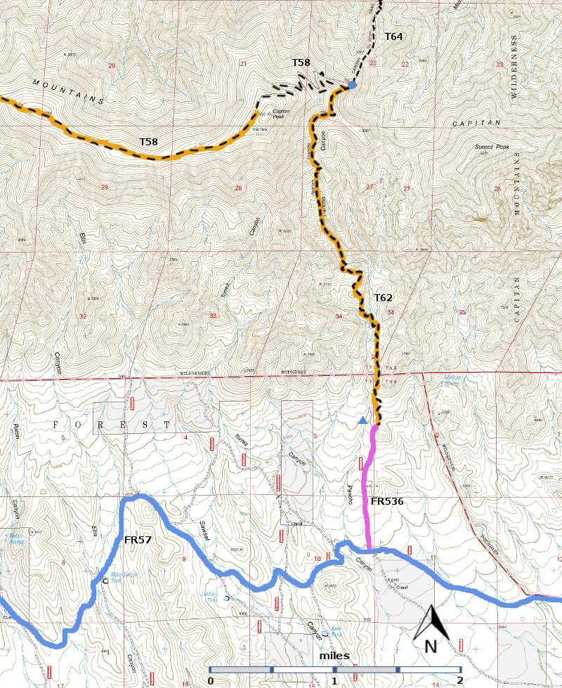
After the first mile from its lower end, T62 gradually becomes an
intermittently steep trail of 30% to 50% gradient. In 2001, evidence of the 1994 Pancho Canyon
Fire, including a scattering of fallen logs across the trail, began at about
mile 1.7. Further on, frequent piles of
fallen timber were scrambled over. Riparian
areas were scattered from mile 0.4 to mile 2.4.
At mile 1.0, a stream flowed at about 30 gallons per minute in 1994;
when the area was visited in 2001 it was dry, although small puddles existed
just down canyon.
Distant
views are best near the lower end. Very
dramatic effects of the forest fire, interesting landforms, and scenery appear
along the trail including the “balanced” rock at mile 1.7. A fascinating scree slope is crossed at mile
3.1 in the upper basin.
ACCESS:
Although,
hypothetically, the trail can be accessed from either its lower or upper
terminus, the only way to currently reach it and stay on the path for a couple
of miles is from its lower trailhead.
From the upper end, although signed, trail tread becomes obscure
immediately and, unless one has knowledge of where the path should proceed,
getting lost is guaranteed!
To
reach the lower T 61 trailhead, a high clearance vehicle is needed. Begin in
Capitan at the intersection of US380 and NM246. Drive US380 east 8.4 miles to
County Road C 002, also signed as FR57. Note two roads going left
within about ten feet of each other. The one on the right goes to a picnic
area.
The
one on the left, FR57, begins as a well-graveled road and at mile 5.3, passes
Baca Campground [Site of a 1930’s CCC camp; ruins are still visible]. At mile 6.3, county road maintenance
ends. County Road C005 begins, and goes
straight ahead; but don’t follow it.
Instead, turn left on FR57, an unmaintained road. Maximum speed here may be 10 mph. At mile 7.7 is T61, the Pierce Canyon Trail
terminus, on the highest point along this road. Beyond this ridge, FR57
deteriorates even more with some severe erosion for another 6.8 miles before
reaching FR536 on the left. The lower signed trailhead is accessed by driving,
or walking (strongly recommended), the very rough FR536 north 1.0 mile from its
beginning off FR57. Note from Lynn
Melton: We mean ROUGH – big rocks with
scrape marks on them where someone bottomed out on this road.]
At
the north end of FR536, an old wooden sign and “hiker sign” mark the trailhead.
Two cairns on the right do not lead to a
visible tail. Stand facing the large
rock behind an alligator bark juniper. Scramble uphill, passing to the let of
the large rock. You should reach T62 (and
a large cairn) after about 30 yards.
To
reach the unusable upper trailhead for T62 at its common junction with T64,
Capitan Peak Trail, and T58, Summit Trail, consult write-ups for those
trails. | 


