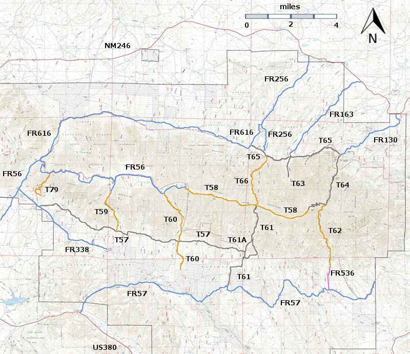
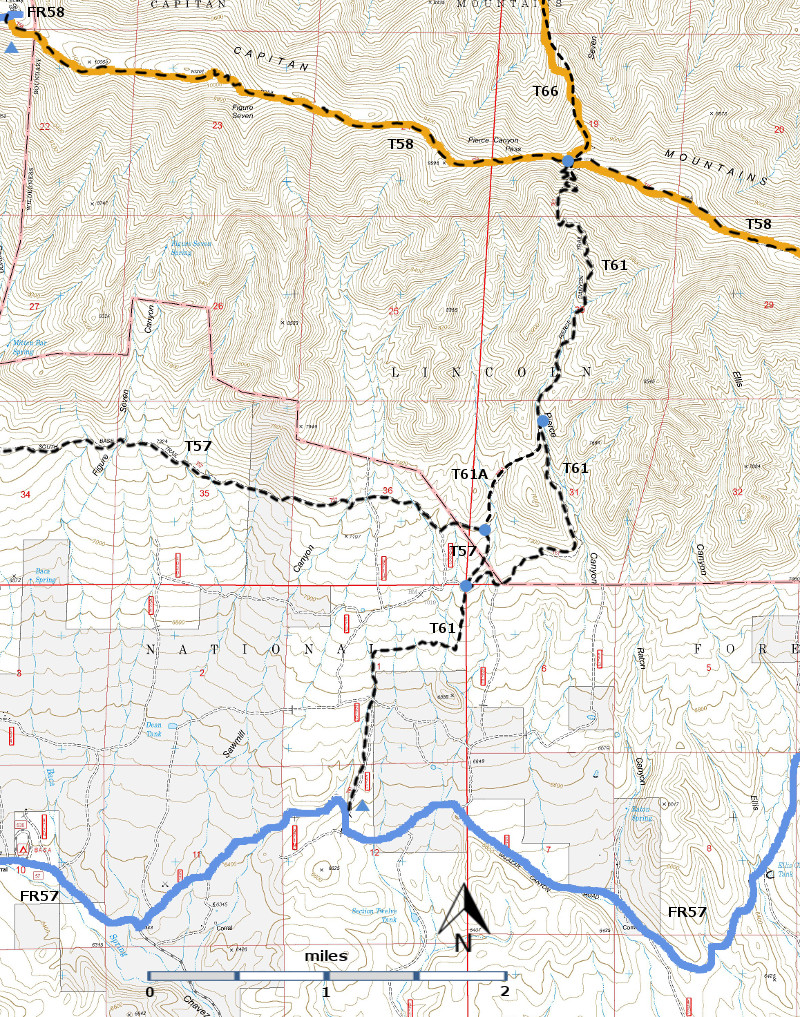
DESCRIPTION:
T61
provides a relatively moderate grade to the main ridge of the Capitan
Mountains. In fact, on the south side of
these mountains, this is the easiest climb along any trail. The path is obscure in a few locations.
Maximum gradient reaches 30% infrequently, though usually it is much less.
The
trail passes the eastern end of T57, South Base Trail, at mile 2.0 from its lower
end at FR57. At mile 3.4 is a nice 20 foot high cascade, one of few water
sources along the route, including the signed but minuscule and undependable
Pierce Spring at mile 4.8. At mile 3.6,
just before reaching an old Pierce Canyon sign, is the unsigned T61A junction
in a small narrow meadow. After mile 4.0
along T61, the mixed conifer forest takes on a mature appearance.
The
best distant view is just off the trail at mile 4.9. To see it, carefully follow a narrow ridge to
the left for 250 feet from the end of a switchback situated on a sharp
ridge. Most other views are variously
filtered. No meadows are present, although the trail passes a variety of
landscapes, including another impressive, narrow ridge beginning at mile 5.0
for 0.2 mile.
If
a round trip is made by ascending T61, a good chance exists that T61A will be
taken unintentionally on the return trip, since no signs show the junction.
(This happened to me.) Using unsigned T61A
is 0.4 mile shorter but much rougher.
T61
and T66, Seven Cabins Trail, together make an ideal hiking route across the
Capitan Mountains if transportation can be arranged at the lower end of T66. Try taking a two day hike, and camp on the
ridge near the convergence of T61 and T66 at the intersection with T58, Summit
Trail.
ACCESS:
To
reach the lower T61 trailhead, a high clearance vehicle is needed. Begin in
Capitan at the intersection of US380 and NM246.
Drive US380 east 8.4 miles to County Road C002, also signed as FR57. Note two roads going left within about
ten feet of each other. The one on the right goes to a picnic area.
The
one on the left, FR57, begins as a well-graveled road and at mile 5.3, passes
Baca Campground. [Site of a 1930’s CCC camp; some ruins are still visible.] At mile 6.3, county road maintenance
ends. County Road C005 begins, and goes
straight ahead; but don’t follow it.
Instead, turn left on FR57, an unmaintained road. Maximum speed here may be 10 mph. At mile 7.8, the signed T61 trailhead is to
the left on a minor ridge, the highest point along this road.
To
reach the upper trailhead for T61, hike T58
3.7 miles from its western trailhead off FR56, or hike 3.7 miles up T66,
Seven Cabins Trail, from its lower trailhead. See the write-ups for T58 and T66
to access these trails.
| 


