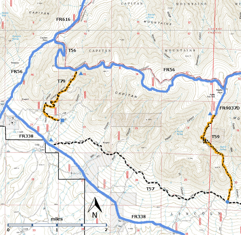
T59
Padilla Trail


Smokey Bear Ranger District
TL-yellow-190.jpg
Download
T59
GPS Track
(as .GPX)
Capitan Mountains Trails
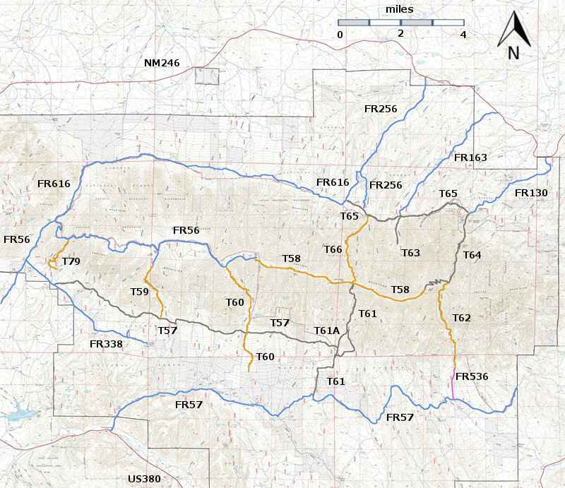
T57 (partial), T59, and T79 are shown as black dashed lines on the map.
These trails are not within the Capitan Mountains Wilderness Area, but as p
art of the Capitan
Mountains Wilderness Area trail system, these trail allow only hiking and pack animal activities.
Capitan-mc-RTS-r8p5.jpg

Capitan-mc-RTS-cb1a-rf.jpg

LENGTH:
2.7 miles
ELEVATION:
7200 - 9440 ft
2240 ft

difference
DIFFICULTY:
Most Difficult
SCENIC
RATING:
3
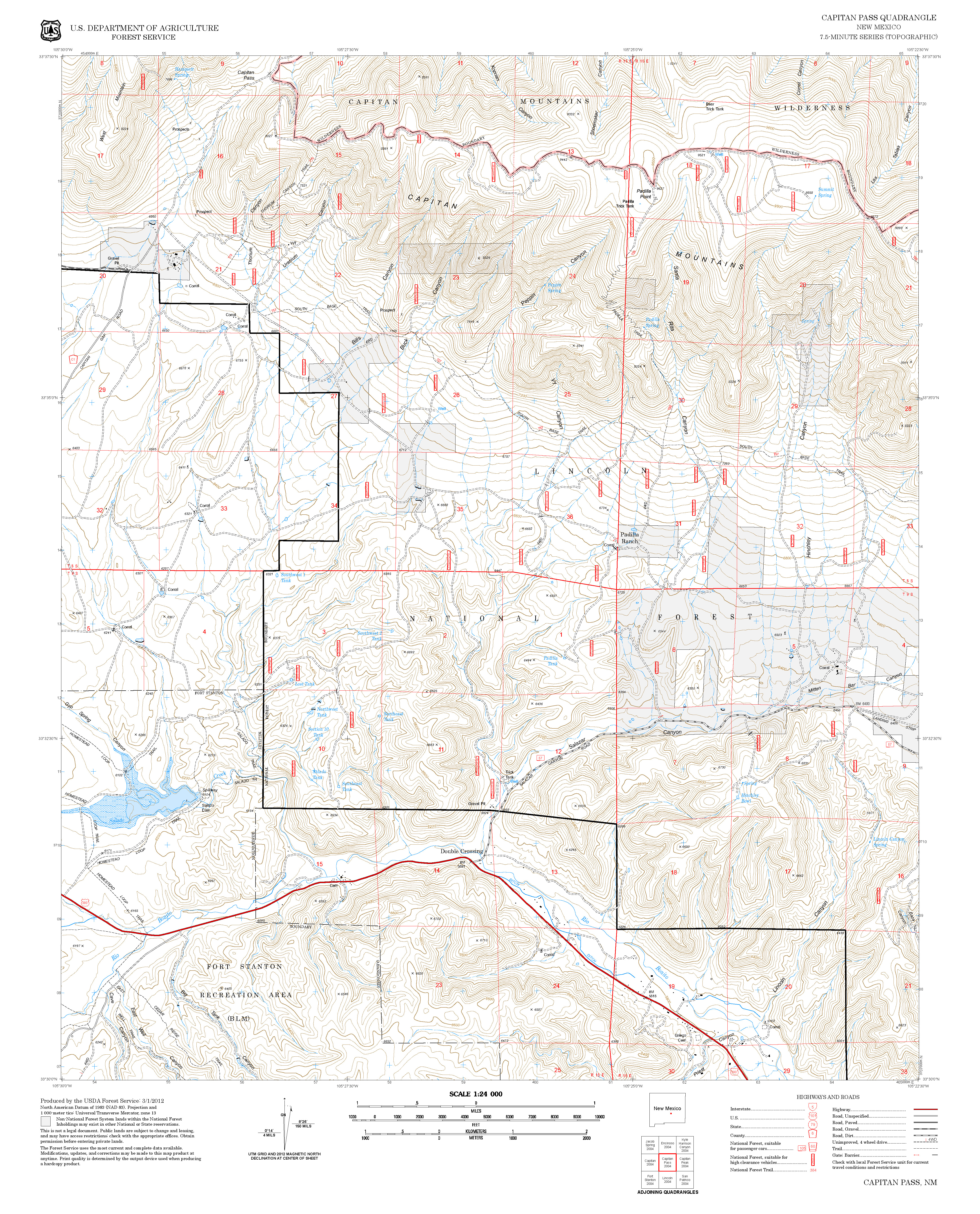
Contour Interval: 40 feet
Capitan Mountains Area  (37 MB)

Capitan Pass Topo Map
Route Color Codespaved roads
(red)
FS roads, open
(blue)
FS roads, closed or impassable
(magenta)
main trail(s)
(black dashes)
---connector trail(s)
(green dashes)
---damaged or intermittent trail(s)
(orange over black dashes)
---closed trails(s)
(red over black dashes)
---
Symbolstrailhead
(blue triangle)
blue-triangle.jpgtrail junction
(blue dot)
blue-dot.jpgtrail end
(blue square)
blue-square.jpg

DESCRIPTION:

T59 has great vegetational diversity and is one of two trails descending the south side of the Capitan Mountains that can be reasonably accessed by a suitable vehicle from both its upper and lower trailheads. At 0.8 mile from the junction of FR56 and FR9037D, the trail leaves the primitive road (which leads to a 10-acre mountain meadow) by angling left at a two foot high rock pile 20 feet ahead of a wooden T59 sign, just before the road turns right.   Although barely discernible for 200 feet, signed T59 soon becomes obvious when flanked by rocks, and heads down through thick forest. Distant views are few and usually highly filtered through trees. Between mile 0.2 and 1.5 gradients are generally steep, 25% to 35% being common, requiring at least 40 switchbacks. 

 At mile 1.5, near a campsite, is unique Padilla Spring, consisting of a multitude of seeps and small springs.  Water issues from several locations along a horizontal rock layer for several tens of feet. A few of the resulting streamlets join together just above where the trail crosses the main stream. At this crossing is also the mouth of another stream, equal in volume to the others combined, emerging from a nearby depression caused by an uprooted tree that fell years ago. Output from these combined sources is estimated at 15 to 20 gallons per minute (1994).

Below Padilla Spring for 0.7 mile, the trail parallels the stream and passes several seeps. For the most part, the route is easy to discern. The lowest portion follows a primitive road, ending at the signed lower trail junction.

It is strongly recommended that hikers and equestrians descend the trail due to the path’s general steepness. The one exception is if your destination is the Padilla Spring area just 0.8 mile up canyon from the lower trail end.

 ACCESS:

A high clearance vehicle is required for both trailheads; 4‑wheel drive is strongly recommended for FR56. To reach the upper trailhead, begin in Capitan at the New Mexico NM48 and US380 intersection. Drive US380 east 2.0 miles to County Road C001, also known as FR56, Capitan Pass Road.  At mile 5.4, the maintained road turns right and becomes FR338, also signed County Road C003. Do not turn right.  Instead, proceed straight ahead on a rutty set of tracks signed as FR56 that gives way to a rough route. Do not attempt if wet.  At mile 7.1 (on Capitan Pass), turn right and continue following FR56, which soon becomes steep and rocky until a ridge is reached at mile 9.3.  Beyond here, the road is periodically rocky and rough to mile 12.2, and the largest meadow encountered on the Capitan Mountain ridge. There is a large sign for T59 and a sign for FR9037D, which leads to the right.  The actual T59 trailhead is 0.8 miles down FR9037D, which is rough in spots.  You may decide to park along FR9037D and hike to the actual trailhead and it old wooden sign.

To reach the lower trail junction, turn right at mile 5.4 (above) off of FR56 and follow the graveled road FR338 (also County Road C003. The maintained section soon ends at mile 0.3 where it enters Lone Tree Bible Camp.  Do not enter the camp, but continue straight ahead. This is unsigned FR338 and it is a dry weather road and is quite rough.  Driving speed may be five miles per hours or less.  At mile 4.2 from FR56, just after passing a draw labeled Peppin Canyon, [GPS coordinates for this hard-to-find junction are given below] turn left on unsigned FR9796A and follow a faint double track straight ahead for 0.5 mile through a barbed wire gate.  Continue following vague eroded tracks to an unmarked, open area for parking; a somewhat hidden, two foot high rock cairn is on the right. This marks the beginning of the unsigned, rugged, 0.4 mile spur trail that tees into T57, South Base Trail, at a signed junction. This connecting route is tricky to follow.  Once on T57, turn right and hike 0.8 mile to the signed junction with T59.

LOCATION(S) OF ACCESS POINT(S)
Lat/Lon hddd mm ss.sUTM/NAD83
Trailhead (North)N33 36 06.3
W105 24 59.6
13 S
461354
3718079
Junction of T57 and T59N33 34 38.7
W105 24 44.0
 13 S
461745
3715379
Junction of FR338 and FR9796AN33 34 10.3
W105 25 56.5
13 S
459872
3714512

Last Hiked:  2001Web Page Updated:February 20, 2014
Copyright Lynn Melton 2014Contact: LNFTG14@gmail.com