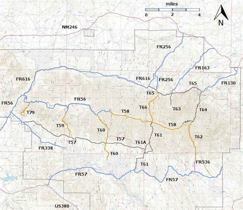
DESCRIPTION:
The
highest and most scenic trail in the Capitan Mountains Wilderness, this path is
often flanked by rocks or may become vague when passing through meadows. It
follows the main ridge of the Capitans between the western T58 trailhead and
its eastern end (beyond Capitan Peak).
Beginning
at its western end, at mile 1.1, the trail passes the highest point (not
officially designated) on the Capitan Mountains at 10,201 feet. The somewhat
vague high point can be missed if not anticipated because it is not signed on
the trail. Distant views are not possible from this high point.
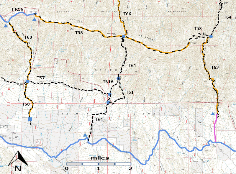
T58
passes through mature forests of spruce, white fir, Douglas‑fir, southwestern
white pine, and quaking aspen, and a number of outstanding meadows.
Surprisingly, the meadows make up only about 8% of the trail's environment.
The
path favors the south side of the ridge until mile 2.9. Once on the north side,
a more delineated route passes through fewer meadows and generally younger but
denser trees than on the south exposure.
Several
hills along the ridge have gradients averaging 10% to 15%, with 25% being the
maximum. Trees surrounding the occasional meadows frequently obstruct distant
views. Grand panoramas are best from the Capitan Peak area, which is off the
trail but can be reached. At mile 6.5,
1.6 miles before the trail ends, the route passes its highest elevation (9,880
feet) on the north side of the peak, near a wooden sign giving direction to
Capitan Peak. There is no trail to the peak, and hiking the minimum of 0.2 mile
cross-country and 200 feet gain in elevation to it is difficult due to
vegetation, rough terrain, and steepness. However, a panoramic viewing bonanza
awaits those who do!
T58
provides access to the following trails, in the sequence reached, from its
western trailhead, followed by mileage: T61 and T66 intersection, 3.7 miles; T62
and T64 intersection, 8.1 miles.
ACCESS:
T58 can be reached by using a
high clearance, 4‑wheel drive vehicle, or by hiking up any of the access trails
just mentioned (except T62). To reach its western trailhead, begin in Capitan
at the NM48 and US380 intersection. Drive US380 east 2.0 miles to FR56, Capitan
Pass Road, also known as County Road C001. Turn left and follow FR56 16 miles, to the signed T58 trailhead, near
the end of FR56 at the electronic site on top of the Capitan Mountains.
The
first portion of FR56 is a well-maintained, graveled road. At mile 5.4, the maintained
route turns right and becomes FR338, also known as County Road C003. Do not turn right. Instead, proceed straight ahead over a rutty
set of tracks, signed as FR56, that immediately gives way to a rough, rocky
route. Do not attempt if muddy. At mile 7.1 (on Capitan Pass) from US380, turn
right to continue following FR56.
From
here the road is steep (up to 20% gradient) and rocky, until one reaches a
ridge at mile 9.3. Beyond here, it is periodically rocky and steep to the T58
trailhead. Park just beyond the trailhead and off the road; don't block FR56.
For accessing T58 from any of the other trails, consult the write-up for each
one.
| 


