T57
South Base Trail


Smokey Bear Ranger District
TL-green-190.jpg 
Download
T57
GPS Track
(as .GPX)
Capitan Mountains Trails
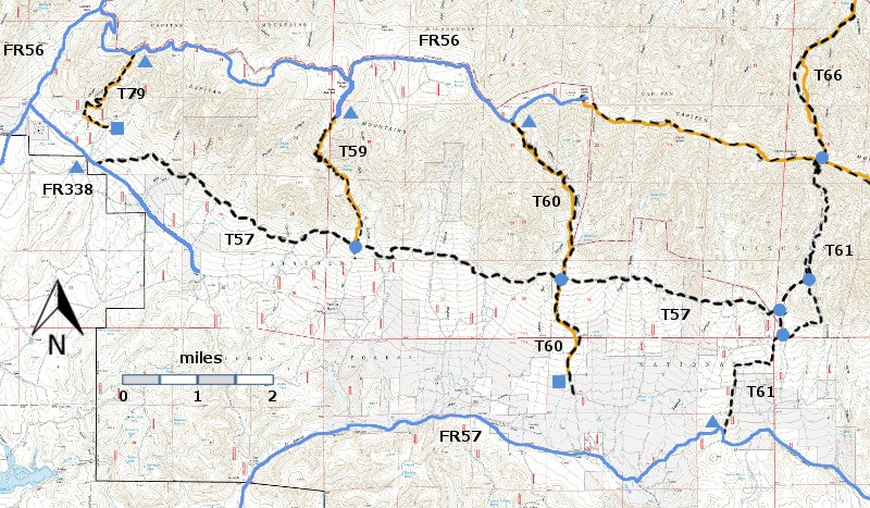
T57, T58 (partial), T59, T60,  T61, T66 (partial), and T79 are shown as black dashed lines on the map. As part of the Capitan Mountains Wilderness Area trail system, these trails allow only hiking and pack animal activities.  
WMW6c2mnr11.jpg 

Capitan-mc-RTS-cb6-rf.jpg

LENGTH:
11.5 miles
ELEVATION:
6720 - 7320 ft
 600 ft

difference
DIFFICULTY:
More Difficult
SCENIC
RATING:
2
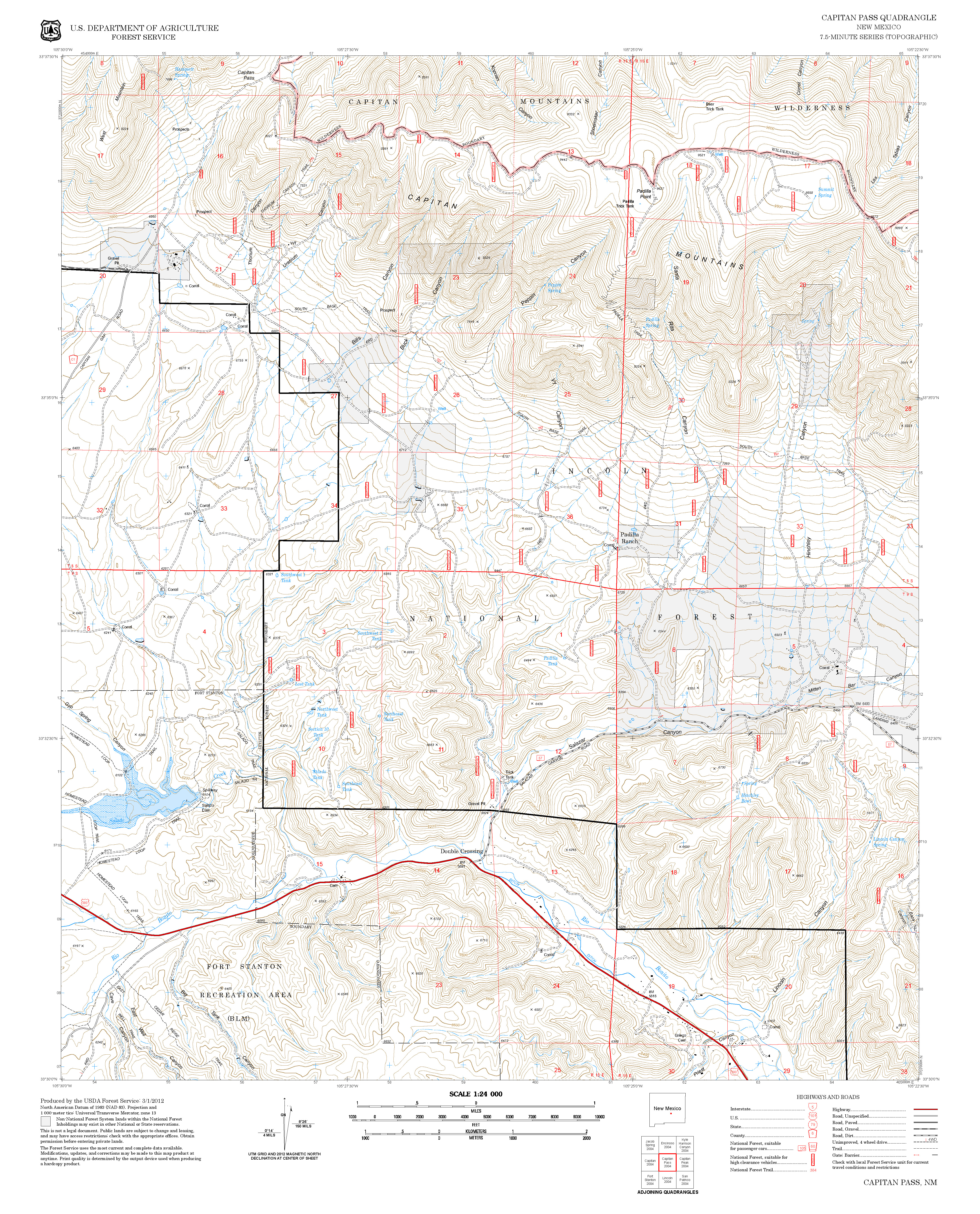
Contour Interval: 40 feet
Capitan Mountains Area  (37 MB)

Capitan Pass Topo Map Capitan Peak Topo Map
Route Color Codespaved roads
(red)
FS roads, open
(blue)
FS roads, closed or impassable
(magenta)
main trail(s)
(black dashes)
---connector trail(s)
(green dashes)
---damaged or intermittent trail(s)
(orange over black dashes)
---closed trails(s)
(red over black dashes)
---
Symbolstrailhead
(blue triangle)
blue-triangle.jpgtrail junction
(blue dot)
blue-dot.jpgtrail end
(blue square)
blue-square.jpg

DESCRIPTION:

T 57 provides the only means of accessing the lower T 60 trailhead and one of two possibilities for reaching the lower T 59 trailhead.  The route extends along the southern base of the Capitan Mountains between its western end on FR 338 (near FR 56) and its eastern terminus on T 61. Path conditions vary considerably, from vague, to a cattle trail, to a very rocky and steep route, to a nice trail often bordered by rocks, to a perfect path covered with pine needles, cones and small broken twigs.  The route is discernible at least 98% of the way. Gradients are usually under 15% with some occasionally ranging 30% or more. Generally, the trail west of the T 60 trailhead is in better shape and more interesting than that to the east. The few distant views are all west of mile 7.7 and are variously filtered through trees.  

 Several primitive, old mining roads and unofficial trails intersect T 57 and may provide interesting side trips

 ACCESS:

T57 is accessible from three locations, each requiring a high clearance vehicle: 

(1) To reach its signed, western trailhead, begin in Capitan at the NM48 and US380 intersection.  Drive US380 2.0 miles east to Forest Road FR56, Capitan Pass Road, also County Road C001.  Turn left and follow FR56 5.4 miles to where the graveled route makes a right turn and becomes FR338, also County Road C003. Follow FR338.  The maintained section soon ends at mile 0.3 where it enters Lone Tree Bible Camp. Do not enter the camp but continue straight ahead. Now unsigned, FR338 becomes a dry weather road and is quite rough.  Follow FR338 another 0.9 mile to the partially hidden sign for the T57 trailhead on the left, just 0.1 mile beyond a large Uranium Canyon sign. Driving speed is often 5 mph or less. 

(2) T57 can be accessed from FR338 at 3.6 trail miles from the western T57 trailhead as follows: Drive primitive FR338 southeast 4.2 miles from its beginning with FR56 to the unsigned junction for FR9796A that goes left (north), just after passing a draw labeled Peppin Canyon [GPS coordinates for this hard-to-find junction are given below.]. Follow FR 9796A, via an obscure double track, for 0.5 mile through a barbed wire gate.  Continue straight ahead, following vague eroded tracks to an unmarked, open area for parking; a somewhat hidden, two foot high rock cairn is on the right. This marks the beginning of an unsigned, 0.4 mile trail that tees into T57. This rough connecting trail is tricky to follow, but T57 is signed when reached.

 (3) The eastern trailhead for T57 is reached by hiking T61, Pierce Canyon Trail, 2.0 miles from its lower trailhead off FR57, Baca Campground Road; see the T61 write-up for its access from FR57. Of the three access routes, this is the most rugged and least interesting.
LOCATION(S) OF ACCESS POINT(S)
Lat/Lon hddd mm ss.sUTM/NAD83
Trailhead (West)N33 35 35.7
W105 28 14.0
13 S
456339
3717158
Junction of FR57 and FR9796AN33 34 10.3
W105 25 56.5
13 S
459872
3714512
Junction of T57 and T61N33 33 36.8
W105 19 01.9
13 S
470558
3713442

Last Hiked:  2001Web Page Updated:February 21, 2014
Copyright Lynn Melton 2014Contact: LNFTG14@gmail.com