| Download T51 GPS Track (as .GPX) | White Mountain Wilderness Trails | ||||||||||||||||||||||||||
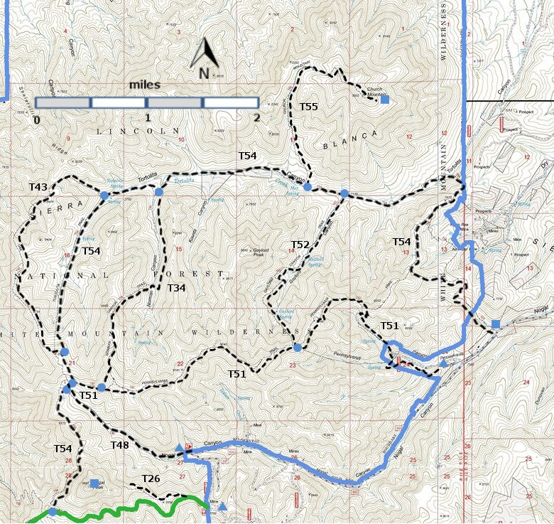
| T26, T34, T43, T48, T51, T52, T54, and T55) are shown as labeled black dashed lines on the map. The solid blue line is the border of the White Mountain Wilderness . The solid green line is T25 Crest Trail. | ||||||||||||||||||||||||||||
 | ||||||||||||||||||||||||||||
| LENGTH: 4.6 miles | |||||||||||||||||||||||||||
|
ELEVATION: 7440 - 9080 ft 1640 ft difference | ||||||||||||||||||||||||||||
| DIFFICULTY: Difficult | ||||||||||||||||||||||||||||
| SCENIC RATING: 4 | ||||||||||||||||||||||||||||
| Download Forest Service Resource | ||||||||||||||||||||||||||||
| Contour Interval: 40 feet White Mountain Wilderness Trails (34 MB) Church Mountain Topo Map Nogal Topo Map | ||||||||||||||||||||||||||||
| ||||||||||||||||||||||||||||
| NOTE: The lower end of T 51 is on private property, and is subject to closure at any time. | ||||||||||||||||||||||||||||
DESCRIPTION: This trail provides more diversity than most,
and is therefore quite interesting, despite its general steepness. Beginning at its lower end in a narrow
canyon, the path gradually becomes steeper, up to 50%, as it leaves the canyon
and heads toward a saddle at mile 0.7 from the gate. Ponderosa pine and pinyon are common among
scattered shrubbery. From the saddle,
the trail proceeds with many ups and downs as it snakes its way along the
ridge, reaching a dozen increasingly higher points. It generally follows a barbed wire
fence in disrepair. Keep this fence
in mind when trail evidence is sometimes hard to find. At one location the “main” path turns right
and is likely to get the first time hiker lost!
Here a less conspicuous trail that stays close to the old fence must be
taken; it finally reaches the highest point at about mile 3.6. Grades along the
ridge average as high as 30% with 45% as maximum. Vistas are variously filtered and infrequent,
but on the whole, they increase as the trail nears its high point. Distant views, including some with
360-degrees, become common as one approaches the upper end of the trail. At mile 1.7 from the lower
trailhead is the junction with the signed upper end of T52, Gaylord Canyon
Trail (soon lost if one follows it into Tortolita Canyon). An unofficial trail, used by locals, begins
just 0.1 mile beyond the T52 connection and is marked by a large arrow on the
ground, constructed with rocks. The path
has been improved and, according to a reader, is followable down to the house
and gate mentioned above. To reach the lower T51 trailhead from Smokey
Bear Ranger District Office in Ruidoso, drive New Mexico NM48 north 8.3
miles to NM37. Turn left and follow NM37 northwest 9 miles to milepost 9. Go
another 0.5 mile; turn left on FR400, also known as County Road C015, and
follow the graveled road 4.0 miles to just beyond the wooden Pennsylvania
Canyon sign. Turn right on FR5628 and
drive 0.4 mile to where the primitive road turns right at an “island”
surrounded by road. Parking here is
recommended because space at the end of the road in 0.3 mile is limited, but
one may take a chance that a space might be open there. | ||||||||||||||||||||||||||||
| LOCATION(S) OF ACCESS POINT(S) | ||||||||||||||||||||||||||||
Table
| ||||||||||||||||||||||||||||
| ||||||||||||||||||||||||||||


