| Download T48 GPS Track (as .GPX) | White Mountain Wilderness Trails | ||||||||||||||||||||||||||
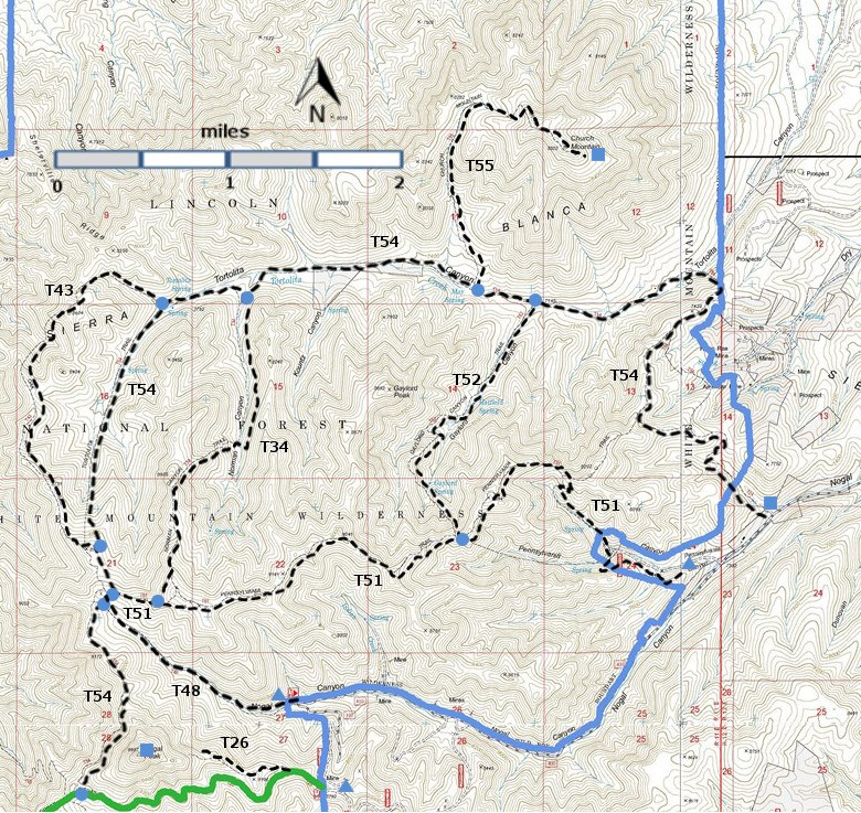
T26, T34, T43, T48, T51, T52, T54, and T55) are shown as labeled black
dashed lines on the
map. The solid blue line is the border of the White Mountain
Wilderness . The solid green line is T25 Crest Trail. | ||||||||||||||||||||||||||||
 | ||||||||||||||||||||||||||||
| LENGTH: 1.4 miles | |||||||||||||||||||||||||||
|
ELEVATION: 8280 - 9060 ft 780 ft difference | ||||||||||||||||||||||||||||
| DIFFICULTY: Moderate | ||||||||||||||||||||||||||||
| SCENIC RATING: 3 | ||||||||||||||||||||||||||||
| Download Forest Service Resource | ||||||||||||||||||||||||||||
| Contour Interval: 40 feet White Mountain Wilderness Trails (34 MB) Church Mountain Topo Map | ||||||||||||||||||||||||||||
| ||||||||||||||||||||||||||||
DESCRIPTION: Check out the following link for more information: http://www.ruidoso.net/visitors/outdoors/trailheads/nogal.html ACCESS: To reach the lower trailhead from Smokey Bear Ranger District Office in Ruidoso, drive NM48 north 8.3 miles to NM37. Turn left and follow NM37 northwest 9 miles to milepost 9. Go another 0.5 mile; turn left on FR400, also known as County Road C015, and follow the graveled, then dirt road 7.2 miles to a sharp left curve, marking the T48 trailhead and the end of FR400. This is also the beginning of FR108, Tanbark Canyon Road. Reaching the T48 trailhead via FR108 from FR107, Rio Bonito Road, is also possible, but a high clearance vehicle and possibly 4‑wheel drive may be required. The distance is 4.4 miles. | ||||||||||||||||||||||||||||
| LOCATION(S) OF ACCESS POINT(S) | ||||||||||||||||||||||||||||
| ||||||||||||||||||||||||||||
| ||||||||||||||||||||||||||||


