| Download T41 GPS Track (as .GPX) | White Mountain Wilderness Trails | ||||||||||||||||||||||||||
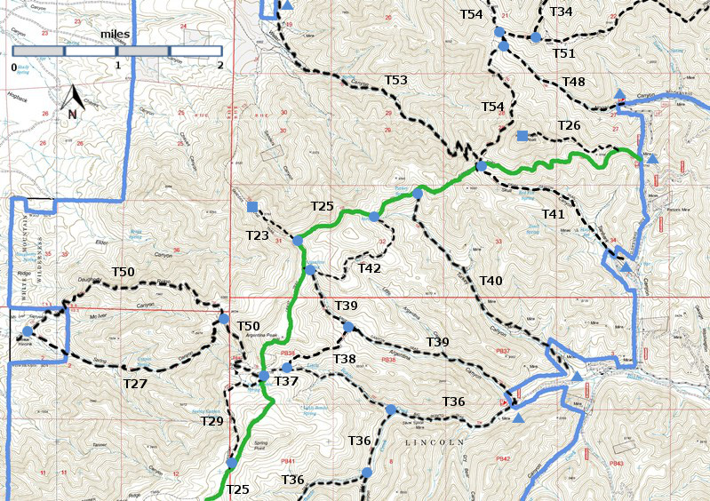
| T23, T26, T27, T29, T34 (partial), T36 (partial), T37, T38, T39, T40, T41, T42, T48, T50, T51 (partial), T53, and T54 (partial) are shown as labeled black dashed lines on the map. The solid blue line is the border of the White Mountain Wilderness . The solid green line is T25 Crest Trail. | ||||||||||||||||||||||||||||
 | ||||||||||||||||||||||||||||
| LENGTH: 1.6 miles | |||||||||||||||||||||||||||
|
ELEVATION: 7940 - 9140 ft 1200 ft difference | ||||||||||||||||||||||||||||
| DIFFICULTY: Moderate | ||||||||||||||||||||||||||||
| SCENIC RATING: 3 | ||||||||||||||||||||||||||||
| Download Forest Service Resource | ||||||||||||||||||||||||||||
| Contour Interval: 40 feet White Mountain Wilderness Trails (34 MB) Church Mountain Topo Map | ||||||||||||||||||||||||||||
| ||||||||||||||||||||||||||||
Signed Skull Springs is reached in 0.2 mile from the lower trailhead. Thereafter, the trail passes through abundant fern growth and considerable stands of Gambel oak where some trees have diameters of one foot or more! The route parallels an intermittent steam, and a few springs including signed Fox Spring at mile 1.0. Trail gradient varies between 15% ‑ 30%. The easy‑to‑follow route passes through few open areas until Nogal Peak comes into view just 0.1 mile beyond Fox Spring. Thereafter, meadows become frequent during the last 0.5 mile of the trail, before reaching its junction with T25. ACCESS: To reach T41 from Smokey Bear Ranger District Office in Ruidoso, drive NM48 north 8.3 miles to NM37. Turn left and travel NM37 1.3 miles to FR107, Rio Bonito Road, signed Bonito Lake. Turn left and follow the narrow, paved, sometimes rough route past Bonito Lake and beyond the end of the pavement to the junction with FR108 at mile 7.1. Turn right and follow a rougher, primitive road for 0.8 mile to the jct of FR108A. Turn left and follow FR108A for 0.3 mile to the T41 trailhead. Parts of FR108A may be so eroded that most vehicles will not be able to proceed. Park and walk the remaining distance to the trailhead. Just 0.2 mile along this primitive road, a short spur on the right goes to a nice primitive camping site. | ||||||||||||||||||||||||||||
| LOCATION(S) OF ACCESS POINT(S) | ||||||||||||||||||||||||||||
| ||||||||||||||||||||||||||||
| ||||||||||||||||||||||||||||


