DESCRIPTION:
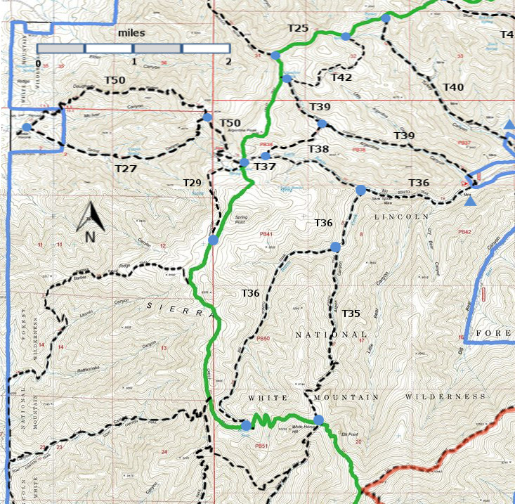
T38 crosses the ridge between Argentina and Little Bonito Canyons. The ridge is an especially scenic spot with a broad, open, and shaded area;
perfect for a rest stop or picnic. Just beyond are incredible high mountain
views toward the south and east. T38 can be part of a relatively short and interesting round trip of 5.0 miles. The least steep way is to hike T36 to T37 to T38, and return along T39. Check out the following link for more information:
http://www.ruidoso.net/visitors/outdoors/trailheads/argentina.html ACCESS:
T38 may be accessed from T37 or T39. To reach T37 or T39 from Smokey Bear Ranger District
Office in Ruidoso, drive NM48 north 8.3 miles to NM37. Turn left
and follow NM37 1.3
miles to FR107,
Rio Bonito Road, signed Bonito Lake. Turn left and follow the narrow,
paved,
sometimes rough road past Bonito Lake, beyond the end of the pavement,
through the
riding stable area, and to the end of the road at mile 8.3. Corrals are
available here for those who bring horses. The corral area is open for
camping. T36 and T39 have a common lower trail head, but the signage
can be confusing. The big yellow and brown sign for T36 is at the end
of FR107, where is should be. The big yellow and brown sign for T39 is
about 0.2 miles prior to the T36 sign, where it should not be. You may
want to park in the open area near the T39 sign and walk to the T36
sign, where there is less room for parking. To add to the confusion,
between the T39 sign and the T36 sign, along FR107, there is a small
sign on the right for the T39 trailhead -- a case of providing signage
for an informal trail. Ignore it.
To
reach the south end of T38, hike T36 1.2 miles to its junction with
T37. Hike T37 1.2 miles to its junction with T38. The junction of T37
with T25 is just 0.2 miles further. To reach the north end of T38,
hike T39 1.6 miles to its junction with T38. | 


