T34
Norman Canyon Trail


Smokey Bear Ranger District
  TL-yellow-190.jpg
Download
T34
GPS Track
(as .GPX)
White Mountain Wilderness Trails

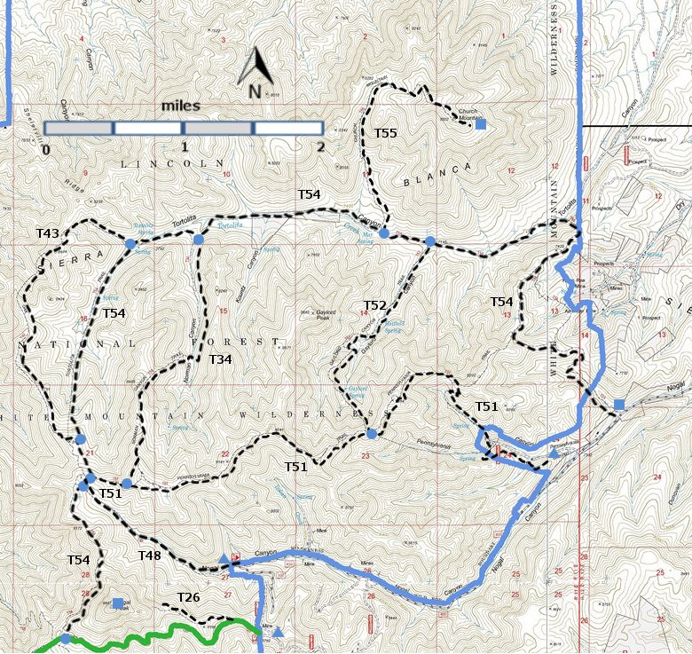
T26, T34, T43, T48, T51, T52, T54,  and T55 are shown as labeled  black dashed lines on the map.  The  solid blue line is the border of the White Mountain Wilderness .  The solid green line is T25 Crest Trail. 

WMW6c2mnr11.jpg 

WMW6c2m-p4cr-RTS.jpg 

LENGTH:
2.2 miles
ELEVATION:
7680 - 9200 ft
1520 ft

difference
DIFFICULTY:
Difficult
SCENIC
RATING:
1
Download
Forest Service
Resource
Contour Interval: 40 feet
White Mountain Wilderness Trails (34 MB)


Church Mountain Topo Map  Nogal Topo Map
Route Color Codespaved roads
(red)
FS roads, open
(blue)
FS roads, closed or impassable
(magenta)
main trail(s)
(black dashes)
---connector trail(s)
(green dashes)
---damaged or intermittent trail(s)
(orange over black dashes)
---closed trails(s)
(red over black dashes)
---
Symbolstrailhead
(blue triangle)
blue-triangle.jpgtrail junction
(blue dot)
blue-dot.jpgtrail end
(blue square)
blue-square.jpg

SPECIAL NOTE:  These primitive trails -- T34, T52, T54, and T55 --are listed because they provide the only means for experiencing this sizable and fascinating canyon.  T54 is the key to all trails in Tortolita Canyon. However, its lower end, the only access to the canyon, crosses private land, and was closed in 1996.  It is not known when a practical access to the lower canyon will be re‑established. Meanwhile, the only realistic way to reach the trail system is from the upper end of the canyon.  See ACCESS below

 All trails in Tortolita Canyon fade out before reaching the surrounding rims because thick shrubbery blocks the moderately steep slopes of the canyon.  I (JWS) was not able to follow any of the trails through these thickets.  However, the upper ends of T34 and T52 access T51, Pennsylvania Trail that, in turn, follows the long, open, beautiful ridge separating Tortolita Canyon from Nogal Canyon.  It is not known if any of the trails in Tortolita Canyon are signed, except the lower end of T55.  For latest information about the Tortolita Canyon Trail System, call Smokey Bear Ranger District Office, 505 257‑4095.

As of 2013, a series of good rock cairns is in place along T34.  It should now be followable.

DESCRIPTION: 

T54 is the longest and best of the four trails. These trails are discussed in order, starting at the upper end of the main canyon and branching off T54.   

From the upper end of Tortolita Canyon, unsigned T34 is the first trail that branches off T54.  It goes up Norman Canyon and, although the lower end threads through partially open under story, it soon passes along a narrow canyon bottom with considerable growth, and then disappears into impenetrable thickets.  It reappears, passing the signed end of T51 on the ridge south of Tortolita Canyon, and terminates at its signed junction with T54. 

 A private house, a landmark in Tortolita Canyon, is located 0.3 mile down canyon from the T34 junction with T54.  According to a reader who hiked this area (early 2000), the signed trailhead for T55 off T54 is a short distance down canyon from the house to the mouth of the unnamed side canyon.  T55 makes its way up this spur canyon through forest and eventually disappears in about a mile.

 Below the house, T54 passes down canyon through several semi‑open and grassy areas. After about an hour of hiking from the T55 junction, the mouth of Gaylord Canyon appears.  The unsigned T52 trailhead off T54 may be difficult to locate; look for a faint set of tracks going south, immediately downstream from where T54 parallels, and then follows an active stream bed for about 75 feet. T52 is an unmaintained trail that has been used by cattle, but is fairly followable to Gaylord Spring. Beyond the spring, the path disappears into impenetrable thickets on the side of the canyon.

 Near the lower end of Tortolita Canyon, the trail passes the remains of the quaint Aquayo Homestead, listed on the National Register of Historic Places.  This historic site is worth exploring!

Check out the following link for more information:
http://www.ruidoso.net/visitors/outdoors/trailheads/nogal.html

 ACCESS:

Since the lower T54 trailhead is now blocked, use T48 to gain access to T54 on the ridge at the head of Nogal Canyon.  See write-up for T 48 to reach this trail.   Follow T54 north.  The route becomes difficult to follow and soon disappears as it approaches the rim above Tortolita Canyon. It reappears in a large meadow in the upper portion of the canyon.
LOCATION(S) OF ACCESS POINT(S)
Table
Lat/Lon hddd mm ss.sUTM/NAD83
Junction of T34 and T54 N33 32 04.8
W105 47 37.2
13 S
426309
3710844
Junction of T34 and T51
N33 30 37.1
W105 48 08.1
13 S
425489
3708150

Last Hiked:  1990Web Page Updated: February 7, 2014
Copyright Lynn Melton 2014Contact: LNFTG14@gmail.com