| Download T33 GPS Track (as .GPX) | White Mountain Wilderness Trails | ||||||||||||||||||||||||||
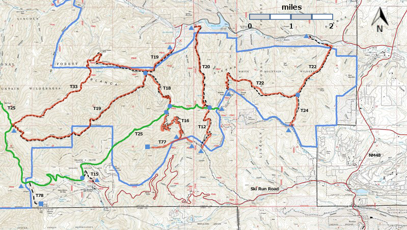
| T12, T15, T16, T18, T19, T20, T20, T24, T77, and T78 are shown as black dashed lines on the map. The solid blue line is the border of the White Mountain Wilderness. The solid green line is T25 Crest Trail. The red over black dashes indicates that the trail is badly damaged and has been closed to the public by Forest Service order. | ||||||||||||||||||||||||||||
 | ||||||||||||||||||||||||||||
| LENGTH: 5.3 miles | |||||||||||||||||||||||||||
|
ELEVATION: 7780 - 10460 ft 2680 ft difference | ||||||||||||||||||||||||||||
| DIFFICULTY: Difficult | ||||||||||||||||||||||||||||
| SCENIC RATING: 4 | ||||||||||||||||||||||||||||
| Download Forest Service Resource | ||||||||||||||||||||||||||||
| Contour Interval: 40 feet White Mountain Wilderness Trails (34 MB) Full Topo Map | ||||||||||||||||||||||||||||
| ||||||||||||||||||||||||||||
| This trail has been badly damaged by the Little Bear Fire and subsequently heavy rains. It has been closed to the public by Forest Service order, and it may never reopen. I have presented John Stockert's description from the 2002 edition of the Trail Guide: Lincoln National Forest. Perhaps his descriptions will help us to remember what we lost. | ||||||||||||||||||||||||||||
DESCRIPTION: T33 branches off T19 0.9 mile up trail from Southfork
Campground. The upper end of T33 is also signed from T19, just 125 feet from
where T19 ties in with T 25. Parts
of T 33 are some of the least discernible and most difficult to follow of any found in this publication. To hike T33, it is strongly recommended to
start from its upper trailhead, after hiking up T19 from the campground. Caution:
allow two days for the loop trip. From its upper end, the path follows a long
ridge for 2.4 miles with incredible panoramic views. Along the first 1.1 miles,
rock cairns generally provide adequate reference points for the path that may
be hard to discern. Beyond that, the ridge includes several steep grades where
the stony trail attains gradients up to 40%. To reach the lower trailhead from Smokey Bear Ranger District Office in Ruidoso, drive NM48 north 8.3 miles to the junction of NM37. Turn left and follow the paved road 1.3 miles to FR107, Rio Bonito Road. Turn left (signed Bonito Lake) and follow the narrow pavement 4.8 miles (past Bonito Lake) to a main road junction at a sign indicating Southfork Campground. Turn left and drive 0.5 mile through Southfork Campground to a dead end at the T19 trailhead. Hike T19 0.9 miles to the signed T33 trailhead. | ||||||||||||||||||||||||||||
| LOCATION(S) OF ACCESS POINT(S) | ||||||||||||||||||||||||||||
| ||||||||||||||||||||||||||||
| ||||||||||||||||||||||||||||


