T26
Nogal Peak Trail


Smokey Bear Ranger District
TL-yellow-190.jpg
Download
T26
GPS Track
(as .GPX)
White Mountain Wilderness Trails
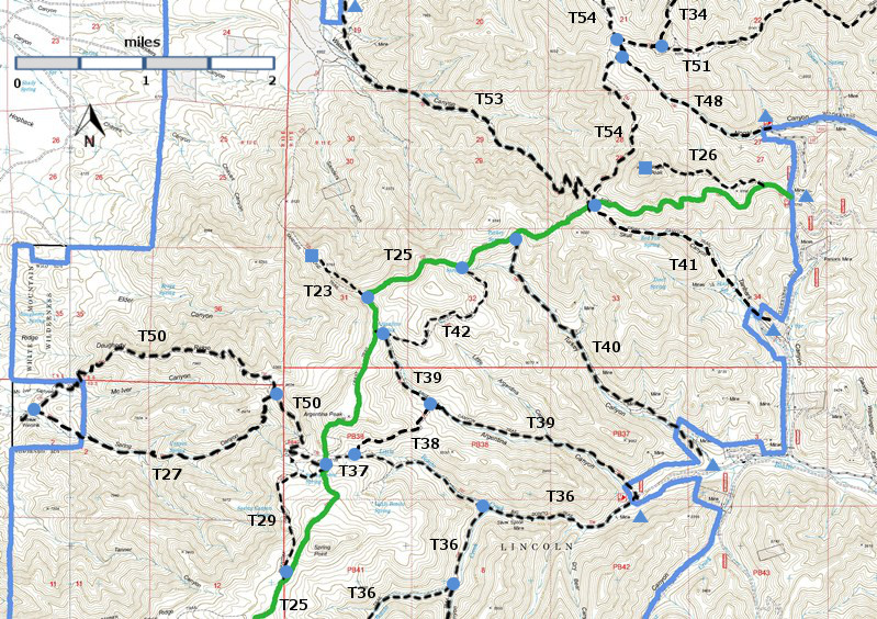
T23, T26, T27, T29, T34 (partial), T36 (partial), T37, T38,  T39, T40, T41, T42, T48, T50, T51 (partial), T53, and T54 (partial) are shown as labeled  black dashed lines on the map.  The  solid blue line is the border of the White Mountain Wilderness .  The solid green line is T25 Crest Trail.
WMW6c2mnr11.jpg

 Trail Map

LENGTH:
1.1 miles
ELEVATION:
8860 - 9920 ft
1060 ft
difference
DIFFICULTY:
Difficult
SCENIC
RATING:
4
Download
Forest Service
Resource
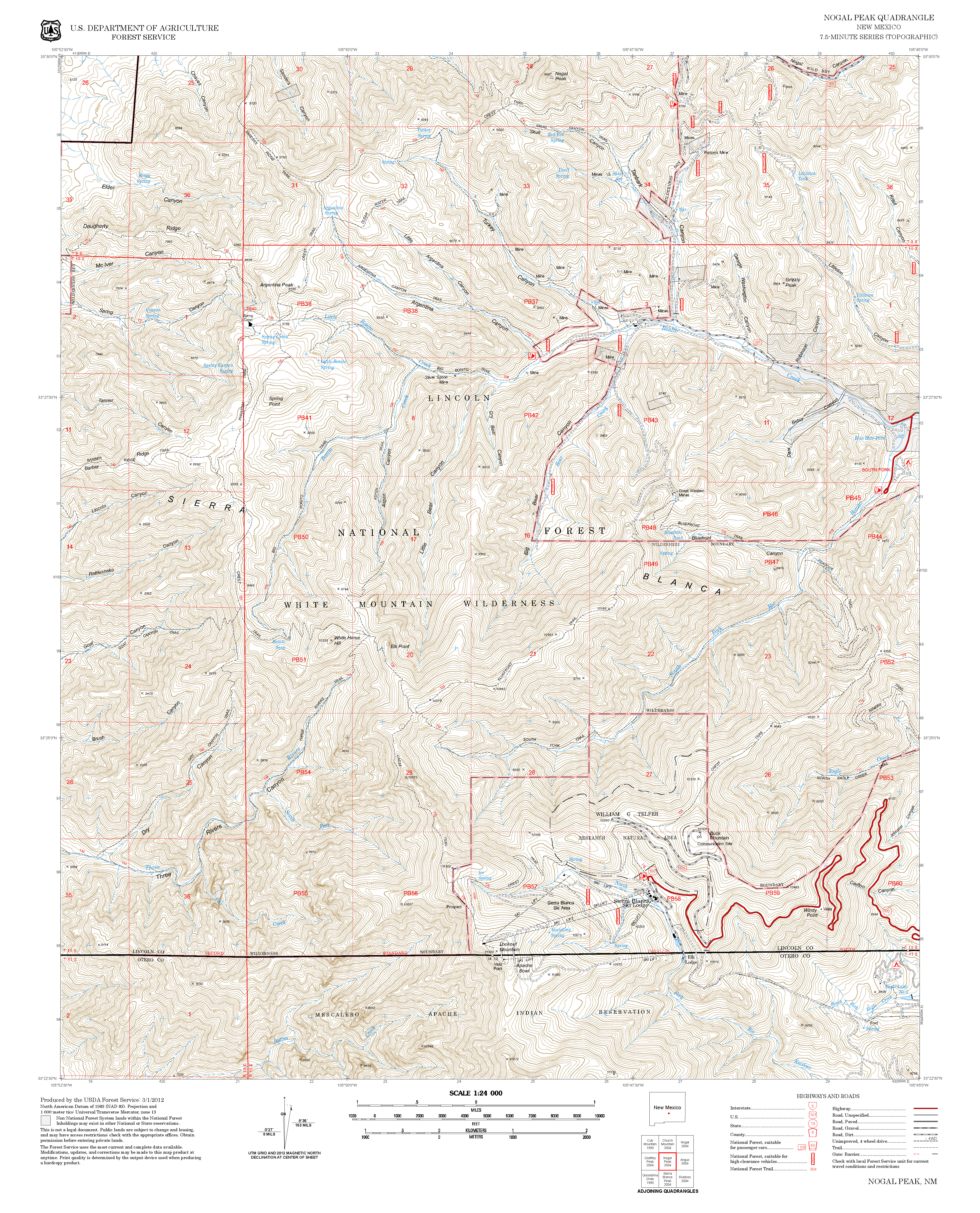
Contour Interval: 40 feet
White Mountain Wilderness Trails (34 MB)

Nogal Peak Topo Map
Route Color Codespaved roads
(red)
FS roads, open
(blue)
FS roads, closed or impassable
(magenta)
main trail(s)
(black dashes)
---connector trail(s)
(green dashes)
---damaged or intermittent trail(s)
(orange over black dashes)
---closed trails(s)
(red over black dashes)
---
Symbolstrailhead
(blue triangle)
blue-triangle.jpgtrail junction
(blue dot)
blue-dot.jpgtrail end
(blue square)
blue-square.jpg

DESCRIPTION:

From its beginning, T26 follows an old fence line through oak and New Mexico locust for about 0.2 mile. Excellent views of Nogal Peak and the surrounding area soon appear. A small secondary peak is reached at mile 0.8 and makes a fine rest stop for preparing to hike the remaining very difficult 0.3 mile. The trail becomes quite rough and hard to discern amid tall grass. After 0.1 mile, the gradient reaches 65% with 0.2 mile still to go!

The trail is unsigned and somewhat obscure in places. From T25 it generally follows a ridge to the summit of Nogal Peak.Conditioned hikers should allow two hours to reach the summit from the T25 trailhead at FR108. In the first 0.8 miles, the trail ascends 400 ft; in the remaining 0.3 miles, it ascends  650 ft. Those who have health problems should not attempt this trail.  However, breathtaking 360-degree views await the exhausted hiker on the summit. Landmarks include much of the White Mountain Wilderness, Monjeau Peak, Sierra Blanca Peak, Tularosa Basin and the White Sands, Carrizozo, Carrizo Peak, Capitan Mountains, and much more.  Wildflowers are abundant in season; at least 50 species may be present.  Short‑horned lizards have also been noted.  In Smokey Bear Ranger District, this is the shortest trail from a road to a grand, 360- degree vista, except from Monjeau Peak.

 You may wish to leave the peak by hiking down its scenic, western slope through a steep, trailless area. Because much oak and New Mexico locust blocks the way and must be negotiated, and bear may be present, this route is not recommended!

ACCESS:  See the T25 write-up to reach its northeastern trailhead off FR108. From here, hike 0.2 mile along T25 to where the end of an old fence line with white-topped steel posts is seen on the uphill side of T25. Turn right and follow an unsigned faint trail from T25 to the fence.  After passing the fence, turn left immediately; follow the trail adjacent to the fence.
LOCATION(S) OF ACCESS POINT(S)
Lat/Lon hddd mm ss.sUTM/NAD83
Summit of Nogal PeakN33 29 50.7
W105 48 12.2
13 S
425373
3706722
Junction of T25 and T26N33 29 46.1
W105 47 16.1
13 S
426820
3706569

Last Hiked:  2001Web Page Updated:February 7, 2014
Copyright Lynn Melton 2014Contact: LNFTG14@gmail.com