| Download T24 GPS Track (as .GPX) | White Mountain Wilderness Trails | ||||||||||||||||||||||||||
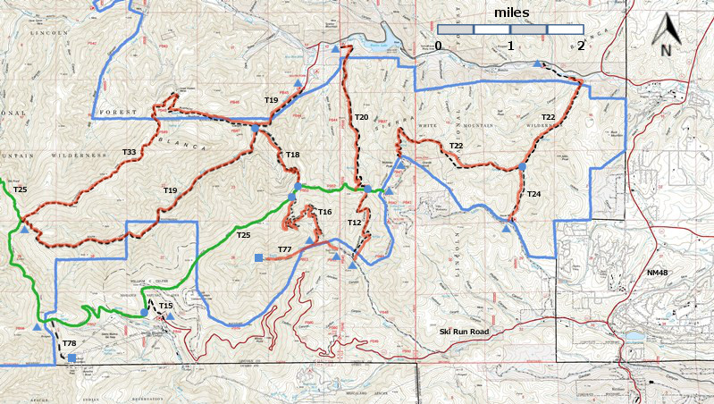
| T12, T15, T16, T18, T19, T20, T20, T24, T77, and T78 are shown as black dashed lines on the map. The solid blue line is the border of the White Mountain Wilderness. The solid green line is T25 Crest Trail. The red over black dashes indicates that the trail is badly damaged and has been closed to the public by Forest Service order. | ||||||||||||||||||||||||||||
 | ||||||||||||||||||||||||||||
| LENGTH: 0.9 miles | |||||||||||||||||||||||||||
|
ELEVATION: 7500 -7920 ft 420 ft difference | ||||||||||||||||||||||||||||
| DIFFICULTY: Easy | ||||||||||||||||||||||||||||
| SCENIC RATING: 1 | ||||||||||||||||||||||||||||
| Download Forest Service Resource | ||||||||||||||||||||||||||||
| Contour Interval: 40 feet White Mountain Wilderness Trails (34 MB) Full Topo Map | ||||||||||||||||||||||||||||
| ||||||||||||||||||||||||||||
| This trail has been badly damaged by the Little Bear Fire and subsequently heavy rains. It has been closed to the public by Forest Service order, and it may never reopen. I have presented John Stockert's description from the 2002 edition of the Trail Guide: Lincoln National Forest. Perhaps his descriptions will help us to remember what we lost. | ||||||||||||||||||||||||||||
DESCRIPTION: T 24 passes through a young Douglas‑fir forest and seldom has water along it. This trail provides a low elevation connection between FR 117 and T 22. When hiking T 22, starting from the upper trailhead is recommended, unless hiking only 2.2 miles from the lower end to reach the T 24 junction.
| ||||||||||||||||||||||||||||
| LOCATION(S) OF ACCESS POINT(S) | ||||||||||||||||||||||||||||
| ||||||||||||||||||||||||||||
| ||||||||||||||||||||||||||||


