| Download T22 GPS Track (as .GPX) | White Mountain Wilderness Trails | ||||||||||||||||||||||||||
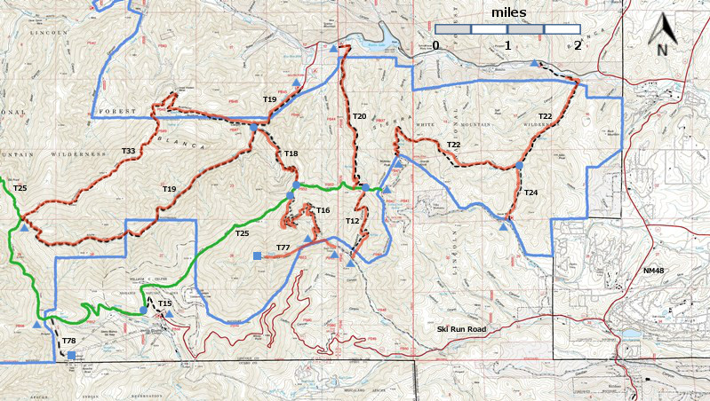
| T12, T15, T16, T18, T19, T20, T20, T24, T77, and T78 are shown as black dashed lines on the map. The solid blue line is the border of the White Mountain Wilderness. The solid green line is T25 Crest Trail. The red over black dashes indicates that the trail is badly damaged and has been closed to the public by Forest Service order. | ||||||||||||||||||||||||||||
 | ||||||||||||||||||||||||||||
| LENGTH: 4.9 miles | |||||||||||||||||||||||||||
|
ELEVATION: 7060 - 9530 ft 2470 ft difference | ||||||||||||||||||||||||||||
| DIFFICULTY: Moderate | ||||||||||||||||||||||||||||
| SCENIC RATING: 3 | ||||||||||||||||||||||||||||
| Download Forest Service Resource | ||||||||||||||||||||||||||||
| Contour Interval: 40 feet White Mountain Wilderness Trails (34 MB) Full Topo Map | ||||||||||||||||||||||||||||
| ||||||||||||||||||||||||||||
DESCRIPTION: T 22, for the most part, is an easily
discernible trail, varying from good to fair condition. It provides a great
variety of vegetation, from heavily wooded forests to meadows. Distant views of the Capitan Mountains and a
portion of Bonito Lake are scattered along its upper 1.3 miles. The forested
areas contain frequent small openings with herbs, including wildflowers amid
grass. The route passes Fox Spring, Mills Spring, and several other interesting
riparian areas, including small intermittent streams. Maximum common gradients are about 25% (35%
maximum) along the 3.1 miles between the upper trailhead and the junction with
T 24, Dry Mills Trail. Grade averages are 10% or less between the T 24 junction
and the lower trailhead. | ||||||||||||||||||||||||||||
| LOCATION(S) OF ACCESS POINT(S) | ||||||||||||||||||||||||||||
| ||||||||||||||||||||||||||||
| ||||||||||||||||||||||||||||


