| Download T20 GPS Track (as .GPX) | White Mountain Wilderness Trails | ||||||||||||||||||||||||||
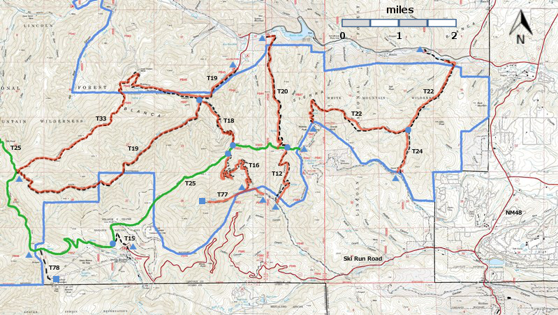
| T12, T15, T16, T18, T19, T20, T20, T24, T77, and T78 are shown as black dashed lines on the map. The solid blue line is the border of the White Mountain Wilderness. The solid green line is T25 Crest Trail. The red over black dashes indicates that the trail is badly damaged and has been closed to the public by Forest Service order. | ||||||||||||||||||||||||||||
 | ||||||||||||||||||||||||||||
| LENGTH: 2.5 miles | |||||||||||||||||||||||||||
|
ELEVATION: 7420 - 9000 ft 1580 ft difference | ||||||||||||||||||||||||||||
| DIFFICULTY: Moderate | ||||||||||||||||||||||||||||
| SCENIC RATING: 3 | ||||||||||||||||||||||||||||
| Download Forest Service Resource | ||||||||||||||||||||||||||||
| Contour Interval: 40 feet White Mountain Wilderness Trails (34 MB) Full Topo Map | ||||||||||||||||||||||||||||
| ||||||||||||||||||||||||||||
| This trail has been badly damaged by the Little Bear Fire and subsequently heavy rains. It has been closed to the public by Forest Service order, and it may never reopen. I have presented John Stockert's description from the 2002 edition of the Trail Guide: Lincoln National Forest. Perhaps his descriptions will help us to remember what we lost. | ||||||||||||||||||||||||||||
DESCRIPTION: The T12 Telephone Canyon Trail and T20 Rodamaker Canyon Trail form one continuous path and are joined on the ridge where T25 crosses them. At this common junction, vistas are spectacular and encompass a large portion of the White Mountain Wilderness! If you walk from one trail to the other, it is suggested that T12 be ascended and T20 be descended, due to the steepness of the latter. The lower end of T12 begins in a recreation residential tract where privately owned homes are on public land. No camping is permitted here. T20 is steep along its upper
section. Views of subalpine meadows are outstanding. The trail moderates in
descent as it begins to pass along an intermittent creek and through a treed
corridor with open understory. Several oak groves, large and quite old, are
present. To locate the lower end of T20
from Smokey Bear Ranger District Office in Ruidoso, drive NM48 north 8.3 miles
to the junction of NM37. Turn left and follow NM37 1.3 miles to FR107, Rio Bonito Road. Turn
left (signed Bonito Lake) and follow the narrow two-lane pavement past Bonito
Lake to a main road junction with a sign indicating "Westlake Campground
1/8 mile." Turn left and drive to
the Westlake Campground entrance. The trailhead is 1/4 mile beyond the
entrance, at the far end of a campground, owned and operated by the City of
Alamogordo. If you drive through the campground to the trailhead, a fee may be
charged, but you may park for free outside the campground and walk to the
trailhead. | ||||||||||||||||||||||||||||
| LOCATION(S) OF ACCESS POINT(S) | ||||||||||||||||||||||||||||
| ||||||||||||||||||||||||||||
| ||||||||||||||||||||||||||||


