T18
Peacock Trail


Smokey Bear Ranger District
  TL-red-190.jpg
Download
T18
GPS Track
(as .GPX)
White Mountain Wilderness Trails
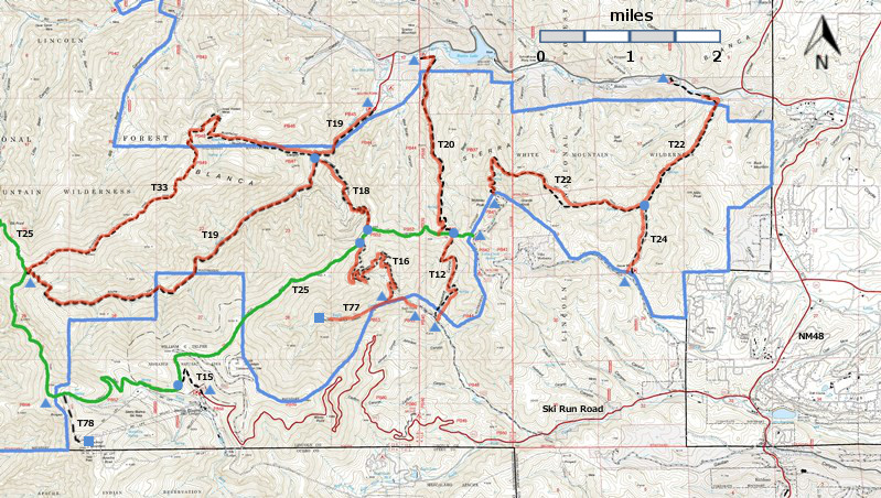
T12, T15, T16, T18, T19, T20, T20, T24, T77, and T78 are shown as black dashed lines on the map.
 The solid blue line is the border of the White Mountain Wilderness.  The solid green line is
T25 Crest Trail.  The red over black dashes indicates that the trail is badly damaged and has
been closed to the public by Forest Service order.
WMW6c2mnr11.jpg

WMW6c2m-p1r-RTS.jpg

LENGTH:
1.5 miles
ELEVATION:
7840 - 9280 ft
1440 ft

difference
DIFFICULTY:
Difficult
SCENIC
RATING:
2
Download
Forest Service
Resource
Contour Interval: 40 feet
White Mountain Wilderness Trails (34 MB

Full Topo Map
Route Color Codespaved roads
(red)
FS roads, open
(blue)
FS roads, closed or impassable
(magenta)
main trail(s)
(black dashes)
---connector trail(s)
(green dashes)
---damaged or intermittent trail(s)
(orange over black dashes)
---closed trails(s)
(red over black dashes)
---
Symbolstrailhead
(blue triangle)
Blue Triangletrail junction
(blue dot)
Blue Dottrail end
(blue square)
Blue Square
This trail has been badly damaged by the Little Bear Fire and subsequently heavy rains.  It has been closed to the public by Forest Service order, and it may never reopen.  I have presented John Stockert's description from the 2002 edition of the Trail Guide: Lincoln National Forest.  Perhaps his descriptions will help us to remember what we lost.

DESCRIPTION:

Named after a Peacock family, T18 provides a quick, but steep connection with T25. Most of the path passes through forest that has never been logged, where timber ranges from small trees to giants three or more feet in diameter. Grades of 35% and higher are common, with 55% maximum. For obvious reasons, it is best to hike down this trail.

ACCESS:

To reach the lower trailhead from Smokey Bear Ranger District Office in Ruidoso, drive NM48 north 8.3 miles to the junction of NM37. Turn left and follow the paved road 1.3 miles to FR107, Rio Bonito Road. Turn left (signed Bonito Lake) and follow the narrow pavement 4.8 miles (past Bonito Lake) to a main road junction at a sign indicating Southfork Campground. Turn left and drive 0.5 mile through Southfork Campground to a dead end at the T19 trailhead. To reach the lower T18 trailhead, follow T19  1.0 mile to the signed intersection for the lower T 18 trailhead on the left.

 To reach the upper T18 trailhead from Smokey Bear Ranger District Office, drive NM48 north 4.2 miles to NM532, Ski Run Highway. Turn left and follow paved NM 532 0.9 mile to the junction of FR117, Monjeau Lookout Road. Turn right and follow the partly graveled road 5.6 miles to the signed beginning of T25, Crest Trail. Turn left and park. Follow T25  1.4 miles to the T18 trailhead.

LOCATION(S) OF ACCESS POINT(S)
Lat/Lon hddd mm ss.sUTM/NAD83
Junction of T18 and T25N33 25 35.9
W105 45 22.4
13S
429699
3698841
Lower TrailheadN33 26 18.2
W105 45 57.9
13 S
428792
3700150

Last Hiked:  2001Web Page Updated:February 5, 2014
Copyright Lynn Melton 2014Contact: LNFTG14@gmail.com