| Download T16 GPS Track (as .GPX) | White Mountain Wilderness Trails | ||||||||||||||||||||||||||
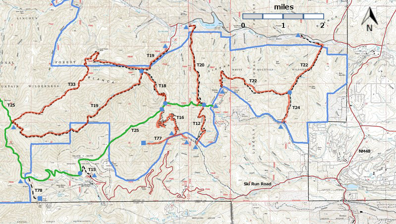
| T12, T15, T16, T18, T19, T20, T20, T24, T77, and T78 are shown as black dashed lines on the map. The solid blue line is the border of the White Mountain Wilderness. The solid green line is T25 Crest Trail. The red over black dashes indicates that the trail is badly damaged and has been closed to the public by Forest Service order. | ||||||||||||||||||||||||||||
 | ||||||||||||||||||||||||||||
| LENGTH: 2.8 miles | |||||||||||||||||||||||||||
|
ELEVATION: 8160 - 9200 ft 1040 ft difference | ||||||||||||||||||||||||||||
| DIFFICULTY: Difficult | ||||||||||||||||||||||||||||
| SCENIC RATING: ? | ||||||||||||||||||||||||||||
| Download Forest Service Resource | ||||||||||||||||||||||||||||
| Contour Interval: 40 feet White Mountain Wilderness Trails (34 MB) Full Topo Map | ||||||||||||||||||||||||||||
| ||||||||||||||||||||||||||||
| This trail has been badly damaged by the Little Bear Fire and subsequently heavy rains. It has been closed to the public by Forest Service order, and it may never reopen. | ||||||||||||||||||||||||||||
DESCRIPTION: T16 Miner's Road Trail is not in the 2002 Edition of Trail Guide: Lincoln National Forest, and I have not hiked it. A handout from the Forest Service describes it as DIFFICULT. Because hikers must leave their vehicle at the locked gate, the hike is 1.2 miles longer than than actual T16 distance. Total distance 2.8 + 1.2 = 4.0 miles. ACCESS: To access the lower end of T16 from Smokey Bear Ranger District Office in Ruidoso, drive NM48 north 4.2 miles to the junction of NM532, Ski Run Highway. Turn left and follow paved NM532 2.5 miles to the junction of Forest Road FR127A, Eagle Creek Road. Turn right and drive the largely graveled and narrow FR127 1.4 miles to the locked gate to the Eagle Creek area. Park and hike 0.8 miles to the trailhead for T77 near Eagle Creek Lodge. Hike 0.4 miles up T77 to the lower trailhead for T16. | ||||||||||||||||||||||||||||
| LOCATION(S) OF ACCESS POINT(S) | ||||||||||||||||||||||||||||
| ||||||||||||||||||||||||||||
| ||||||||||||||||||||||||||||


