T15
Scenic Trail


Smokey Bear Ranger District
TL-green-190.jpg 
Download
T15
GPS Track
(as .GPX)
White Mountain Wilderness Trails
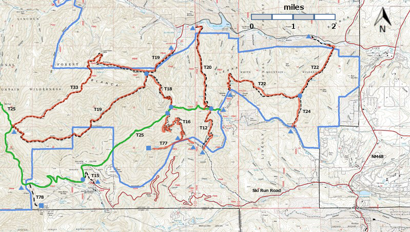
T12, T15, T16, T18, T19, T20, T20, T24, T77, and T78 are shown as black dashed lines on the map.
 The solid blue line is the border of the White Mountain Wilderness.  The solid green line is
T25 Crest Trail.  The red over black dashes indicates that the trail is badly damaged and has
been closed to the public by Forest Service order.
T15 is outside the White Mountain Wilderness area. WMW6c2mnr11.jpg 

WMW6c2m-p1r-RTS.jpg 

LENGTH:
0.6 miles
ELEVATION:
9840 - 10180 ft
340 ft

difference
DIFFICULTY:
Difficult
SCENIC
RATING:
3
Download
Forest Service
Resource
Contour Interval: 40 feet
White Mountain Wilderness Trails (34 MB)

Nogal Topo Map
Route Color Codespaved roads
(red)
FS roads, open
(blue)
FS roads, closed or impassable
(magenta)
main trail(s)
(black dashes)
---connector trail(s)
(green dashes)
---damaged or intermittent trail(s)
(orange over black dashes)
---closed trails(s)
(red over black dashes)
---
Symbolstrailhead
(blue triangle)
Blue Triangletrail junction
(blue dot)
Blue Dottrail end
(blue square)
Blue Square

DESCRIPTION:

The trail provides direct access via a fairly easy, steady gradient to the 21.7 mile long T25. Nearby, and within easy access along the route's first 0.3 mile, is an exquisitely beautiful, intermittent mountain stream amid mixed conifers. Here the path also threads through a lovely, wooded corridor of tall mature fir, blended with aspen and spruce.  Surroundings include steep lush meadows where vegetation occasionally reaches six feet high, with adequate moisture.  From June through September, the area is alive with wildflowers.  
Along T15, at mile 0.3 from the lower trailhead, the trail’s only switchback, going left, could be missed.

ACCESS:

To reach the trailhead from Smokey Bear Ranger District Office in Ruidoso, drive NM48 north 4.2 miles to NM532, Ski Run Highway. Turn left and follow paved NM 532 for nearly 12 miles until the signed T15 trailhead is noted on the right at a U‑curve going left, just prior to entering the gated Ski Apache Ski Area.  
After the first 3.2 miles on NM 532, the fairly narrow 2‑lane road becomes somewhat steep with many switchbacks.  Take advantage of the few pullouts to enjoy outstanding views from the most scenic paved road in Lincoln National Forest!

LOCATION(S) OF ACCESS POINT(S)
Lat/Lon hddd mm ss.sUTM/NAD83
Junction of T15 and T25N33 24 01.3
W105 47 36.2
13 S
426220
3695954
Lower TrailheadN33 23 58.3
W105 47 22.1
13 S
426583
3695857

Last Hiked:  2001Web Page Updated:February 5, 2014
Copyright Lynn Melton 2014Contact: LNFTG14@gmail.com