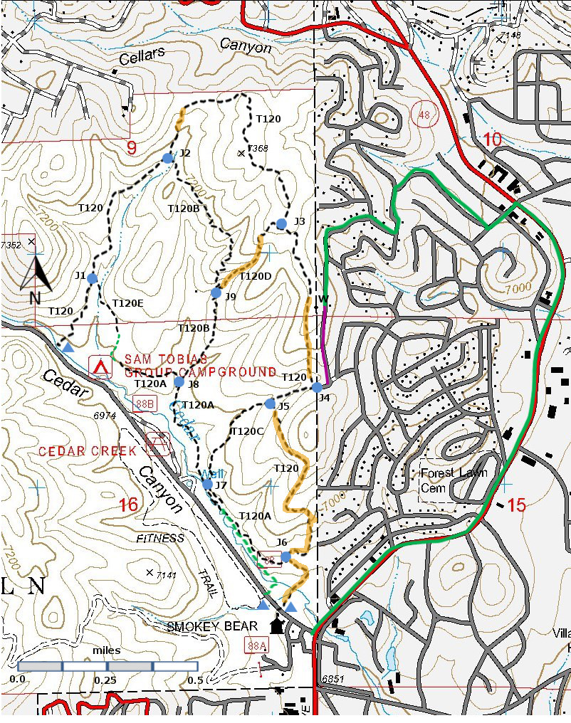
T120D
Spaghetti Bowl D Trail
Smokey Bear Ranger District
|
 |
| Download
T120D
GPS Track
(as .GPX) | Ruidoso Area Trails |
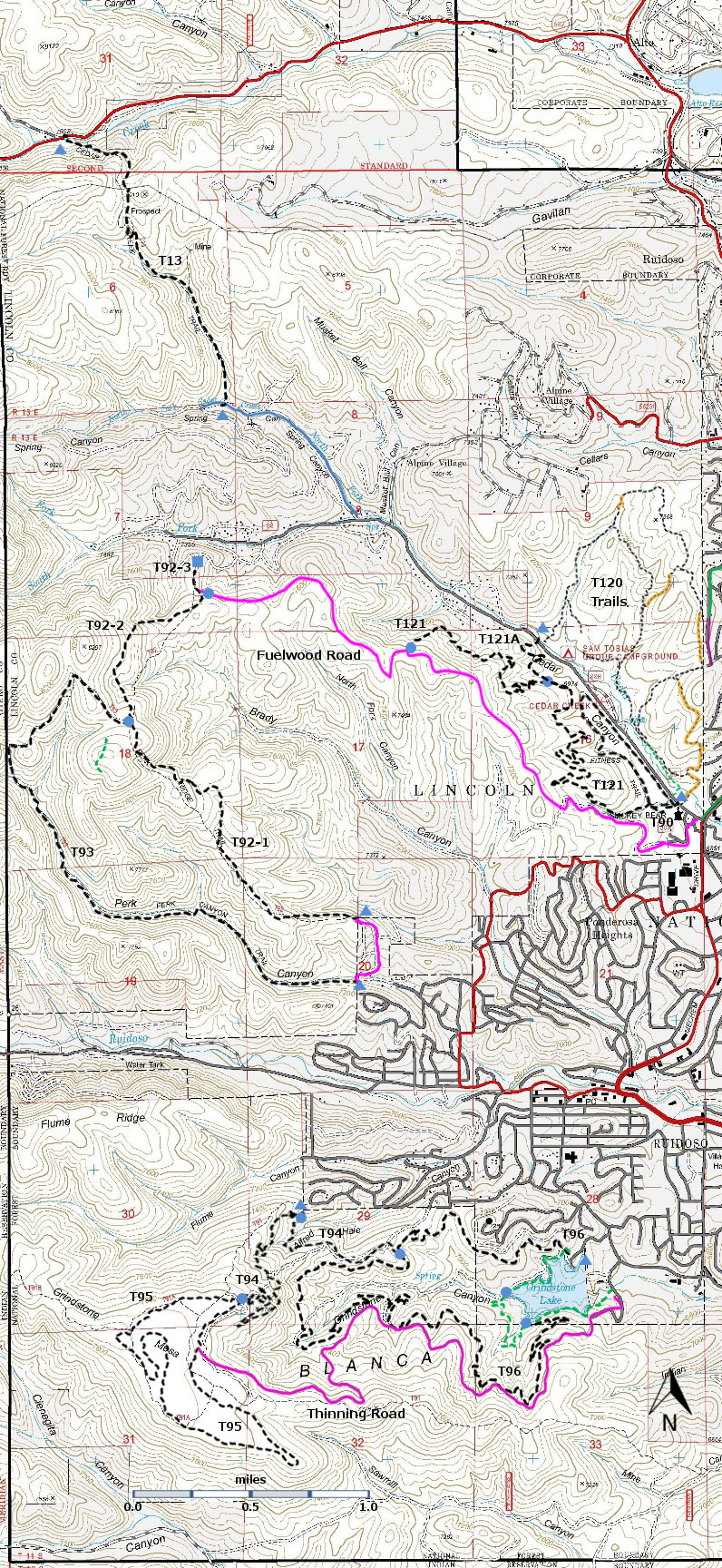
| T120, T120A, T120B, T120C, T120D, and T120E are shown as black dashed lines on the map. | | |
| |
 |
| LENGTH:
0.4 miles
|
|
ELEVATION:
7060 - 7340 ft
280 ft
difference |
|
DIFFICULTY:
Most Difficult |
|
SCENIC
RATING:
1 |
|
Download
Forest Service
Resource |
| |
Contour Interval: 40 feet
Ruidoso Area map
Full Topo Map | |
| |
| Route Color Codes | paved roads
(red) | | FS roads, open
(blue) | | FS roads, closed or impassable
(magenta) | | | | | main trail(s)
(black dashes) | --- | connector trail(s)
(green dashes) | --- | damaged or intermittent trail(s)
(orange over black dashes) | --- | closed trails(s)
(red over black dashes) | --- | | Symbols | trailhead
(blue triangle) |
 | trail junction
(blue dot) |
 | trail end
(blue square) |
 | | |
| |
| |
Note:
The Spaghetti Bowl trails are between the north side of the Sam
Tobias Campground and the surrounding built up areas of Ruidoso.
They may have begun as informal trails, some following old
logging roads. Since about 2010, there has been intensive
thinning of the forest in this area in order to minimize fire danger to
the surrounding areas. As of the end of 2013 the thinning seems
to be ending. There is a lot of forest debris, which will decay
in the next few years. It is likely that the Forest Service will now work on improving the trails and
providing signage.
Even without signage, you should not get
seriously lost. Head downhill and you will come to the Sam Tobias
campground along Cedar Creek Road. | |
| |
DESCRIPTION:
If you are determined to put a check mark next to every listed trail in
the Trail Guide, then you will want to hike T120D once. It is difficult to locate and has only
intermittent stretches that look like someone has been along the path
before. Otherwise, T120D provides an unneeded
opportunity to hike along the bottom of a small rough ravine. On the map, it seems that T120D can be a
connector between the Sam Tobias campground area and the scenic upper portions
of T120. Check out the description of
T120 for better ways to make this connection.
ACCESS:
To access the lower trailhead, hike approximately 0.25 miles along
T120B from the unsigned junction of T120A and T120B [J8]. Look for the ravine on the right [J9]. No signs, no trail. Hike up the ravine.
To access the upper trailhead, hike along T120 approximately 0.2 miles
northwest from the Ruidoso water tower on Catron Road. At an unsigned junction [J3], T120D is the
left fork. The first 100 yards are
decent trail, but it soon worsens. Work
downhill and to the left to enter the ravine. | |
| |
| LOCATION(S) OF ACCESS POINT(S) | |
| |
| |
| Lat/Lon hddd mm ss.s | UTM/NAD83 | Elevation (ft) | Trailhead
Northwest | N33 21 42.5
W105 41 11.1 | 13 S
436139
3691607
| 7010 | | J1 | N33 21 50.8
W105 41 05.9 | 13 S
436275
3691863 | 7050 | | J2 | N33 22 08.9
W105 40 53.5 | 13 S
436600
3692418 | 7190 | | J3 | N33 21 58.7
W105 40 35.5 | 13 S
437063
3692102 | 7320 | | W | N33 21 47.3
W105 40 29.3 | 13 S
437220
3691750 | 7300 | | J4 | N33 21 36.9
W105 40 30.1 | 13 S
437198
3691429 | 7150 | | J5 | N33 21 34.7
W105 40 37.1 | 13 S
437018
3691363 | 7080 | | J6 | N33 21 15.6
W105 40 30.5 | 13 S
437088
3690706 | 6920 | | J7 | N33 21 19.5
W105 40 44.5 | 13 S
436822
3690895 | 6940 | | J8 | N33 21 36.4
W105 40 52.8 | | 6990 | | J9 | N33 21 48.1
W105 40 48.9 | 13 S
436715
3691776 | 7060 | Trailhead
Southeast | N33 21 06.1
W105 40 35.5
| 13 S
437052
3690481
| 6840 |
| |
| Last Hiked: October 30, 2013 | Web Page Updated:January 30, 2014 | | Copyright Lynn Melton 2014 | Contact: LNFTG14@gmail.com |
| |
| |