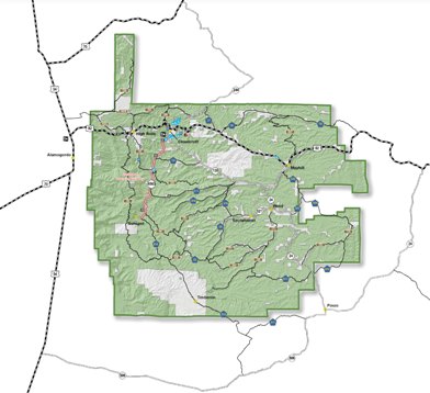
A larger version of this map is available at http://www.fs.usda.gov/main/lincoln/about-forest/districts
General Description
East of Alamogordo is a single mountainous area known locally as the Sacramento Mountains, largely in Sacramento Ranger District. Rising to a height of about 9,600 feet at a few widely scattered places, its timber-covered ridges are sedimentary in origin.
The valley and the adjacent mountain ranges are extraordinary. Between the lowest point in the Tularosa Basin (elevation 3,890 in White Sands National Monument) and Sierra Blanca Peak is a difference of more than 8,100 feet, of which 7,350 feet are within the Forest. This represents the greatest local elevation difference in New Mexico!The logging industry, dating back about 100 years was quite active for seventy years. In order to remove timber, railroads were constructed in several parts of Sacramento Ranger District. Considerable evidence remains of railroad grades and decaying wooden trestles.
Near High Rolls, Pinyon-Juniper Woodlands dominate. At higher elevations Ponderosa pines occur, and the highest parts of the Sacramento Ranger District are Spruce-Fir forest.
Links to Trails
Listing of Trails by Name
Listing of Trails by Number
Listing of Trails by Location
Updates (most recent first)
Services
Routine services -- gasoline, convenience store, cafe -- are available at Cloudcroft, Mayhill, Timberon, and Weed (cafe in Weed, gasoline and convenience store at the intersection of NM 24 and Agua Chiquita Road). Services were formerly available in High Rolls, but that store has closed.
Roads
Paved roads include US 82, NM 24, NM 130, NM6563, and the Sacramento River Road (from Sunspot to Timberon, also signed as County Road C002). FM 64 (also known as Aqua Chiquita Road and NM 521on its eastern portion) is a good gravel road for east-west crossing of the Sacramento Ranger District.
Most of the trails in the Sacramento Ranger District can be accessed by a standard vehicle -- be sure to check the descriptions for the trails. However, there are two notable exceptions. For access to the trails in the Pinon Draw area (southeast part of the Sacramento Ranger District), a high clearance vehicle is recommended. Westside Road (FR90) runs approximately 30 miles from High Rolls to the Sacramento River Road, and its middle section can be muddy, rutted, and extremely slippery when wet. In such times, 4WD and caution are required.
The signage for the road from Sunspot to Timberon is confusing. Some maps show it as Sacramento River Road, and some show it as Sacramento Canyon Road. Along the route, one will not see either name until you are within Timberon. The 2011 Forest Service map shows it signed as County Road E012, whereas the the blue sign visible just past the intersection of NM 6563 and the turnoff to Sunspot is County Road C002. The road is also signed as FR537. Fortunately, the signage confusion does not result in driving confusion. At the intersection of NM 6563 and the turnoff to Sunspot there is only one paved road leading south, and that road is the road from Sunspot to Timberon.
The north end of Westside Road (in High Rolls, near the now-closed convenience store) is signed as Westside Road. It is also FR90, and there are a few FR90 signs along its 30 mile length. However the the south end of Westside Road, the intersection of Westside Road and Sacramento River Road, is not signed at all. To reach this intersection, one drives 6.5 miles south along Sacramento River Road from the intersection of NM6563 and the turnoff to Sunspot. Turn right onto Westside Road. The good news is that, about a quarter mile before the point at which one turns, there is a green highway sign indicating that the turn off to Bug Scuffle is the next right, but there is no indication that this is also Westside Road. Some maps show the southern most portion of Westside Road as FR91.
Maps
In the Sacramento RD, users need two maps: the official Forest Service map (latest edition is 2011) and the Motor Vehicle Usage Map. Both maps may be obtained at the Sacramento RD office, just off NM130 on Lost Lodge Road. The Forest Service map was $10 when I bought mine. The Motor Vehicle Users Map was free. The latter map is updated every few months, so be sure to obtain (and follow) the latest version. The Otero County road map is difficult to obtain and not very useful.
There is another map that I have found useful (but not necessary): New Mexico Game Management - Unit 34 - Cloudcroft Area - Recreation and Game Map. It may be purchased online (paper or electronic version) from BELLGEOGRAPHIC.COM. I bought my paper copy at the Tunnel Shop in High Rolls. It shows a lot of old and closed roads. As the author said to me, "Hunters want to know how they can get that elk out".
Lynn Melton is solely responsible for the content of this web page.
Web Page Updated: January 28, 2014
Copyright Lynn Melton 2013
Contact information: LNFTG14@gmail.com