CAUTION: The Sitting Bull Falls area was badly burned in a
fire in 2011. I have not had a chance to
hike T68 since 2009, and many of the trees in the canyons were probably burned.
The area is recovering, but it may not be as lovely as John Stockert found it
in 2001. His description follows
(amended to include the Junctions).
DESCRIPTION:
Most individuals will begin the trail from the parking area outside Sitting
Bull Falls Recreation Site. A 0.6 mile
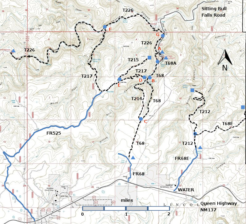
hike from Junction G along T226 brings one to Junction A and T68. [The following
distances are measured from the official trailhead within the (now closed)
Sitting Bull Falls Recreation Area.] The
signed trail is somewhat rough and a little steep at the beginning as it makes
its way via several switchbacks to the canyon floor above the waterfalls. At
mile 0.4 from the trailhead is the turnoff to a short, signed route leading to
the top of Sitting Bull Falls. From mile 0.4
T68 continues up canyon threading through picturesque, semidesert terrain
and vegetation including prickly pear, cholla, juniper, algerita and
cottonwood. The path is occasionally vague and generally stays away from the
thick vegetation paralleling Sitting Bull Creek. Be prepared to do some wading
and/or rock hopping since the trail fords the creek three times, and some wet
areas spread to 30 feet wide.
There
are two significant points of interest. At mile 0.9, take the signed horse
trail to a barbed wire gate (possibly open). Turn right and follow the fence
for a short distance into perhaps the loveliest riparian spot along T 68! An abundance of water greets the eye,
including small ponds and waterfalls, and a unique grotto. BE CAREFUL
since no obvious trail connects this spot with T68 and the exquisite area is
rough to hike around.
The
second point of interest is Sitting Bull Spring at mile 1.1, source for Sitting
Bull Falls.
Consider
hiking a loop of 4.7 miles from the picnic area by including T214. From the picnic area, T214 joins
T68 at mile 0.9 (Junction B) and mile 2.1 (Junction C)
For a longer loop (about 7.3
miles), hike counterclockwise from Junction G along T226 2.2 miles to Junction
F, T217 2.8 miles to Junction E, T217 1.0 miles to Junction D, T214 0.1 miles
to Junction B, T68 0.6 miles to Junction A, and T226 0.6 miles back to Junction
G. Add 2.0 miles round trip if, at
Junction E, T215 is followed to its dead end for a scenic view above the picnic
area.
To
come from the upper end of T68, start from NM 137, or drive a primitive road
0.6 mile from NM 137 to an abandoned cattle-watering facility. Hike north from here, paralleling a
fence (trail is very faint or invisible for 1.0 mile) and pass through two
fence gates (probably open) in quick succession. Immediately after the second gate, at the
trailhead for T214 (Junction B) which goes left, angle right where T68 is a
path outlined by small rocks. Up to this point, the route has passed over dry
terrain on a broad, open tableland of the Guadalupe Mountains.
After
another 0.3 mile, the path turns abruptly left and heads down into a scenic
canyon along a trail constructed by Civilian Conservation Corps in the late
1930s. For the next 0.5 mile, gradients range up to 35%. Canyon wrens are heard
in season. Shortly after passing through a pedestrian gate, Sitting Bull Spring is
on the left, 2.5 miles from the upper trailhead. The stream here marks the
beginning of a fabulous riparian area!
Remember to stay on the upper portion of T68; hikers must not enter the
(now closed) Sitting Bull Falls Recreation Area.
ACCESS:
To reach the lower trailhead, take US285
northwest from Carlsbad (about 12 miles) to 0.6 mile beyond milepost 45 at its
junction with NM137, Queen Highway. Turn left and follow the paved road 22
miles to milepost 32, marking the junction with paved Forest Road FR276,
Sitting Bull Falls Highway (also signed as County Road 409). Turn right and
follow FR276 7 miles to the paved
parking area just before the gate to the Sitting Bull Falls Recreation Site.
To
arrive at the upper trailhead, begin at the junction of US285 and NM137; follow
NM137 32 miles to milepost 20. Then look for a turnoff on the north side of
the road to Guadalupe Ranger District Administrative Site and the public water
hydrant. Continue on NM137 another 1.0
mile (or 0.7 miles beyond milepost 21) to the junction with a primitive road
leading to the right (north). At the
unlocked gated road is a sign for T68. One
can hike from here, or take the very rough road 0.6 mile to an abandoned corral
and cattle watering facility and begin the walk at the official trailhead.
LENGTH:
4.2 miles between New Mexico NM137 and Junction
G; or, 3.6 miles if hiking begins at the abandoned cattle-watering site 0.6
mile from NM137 (upper trailhead).
| 


