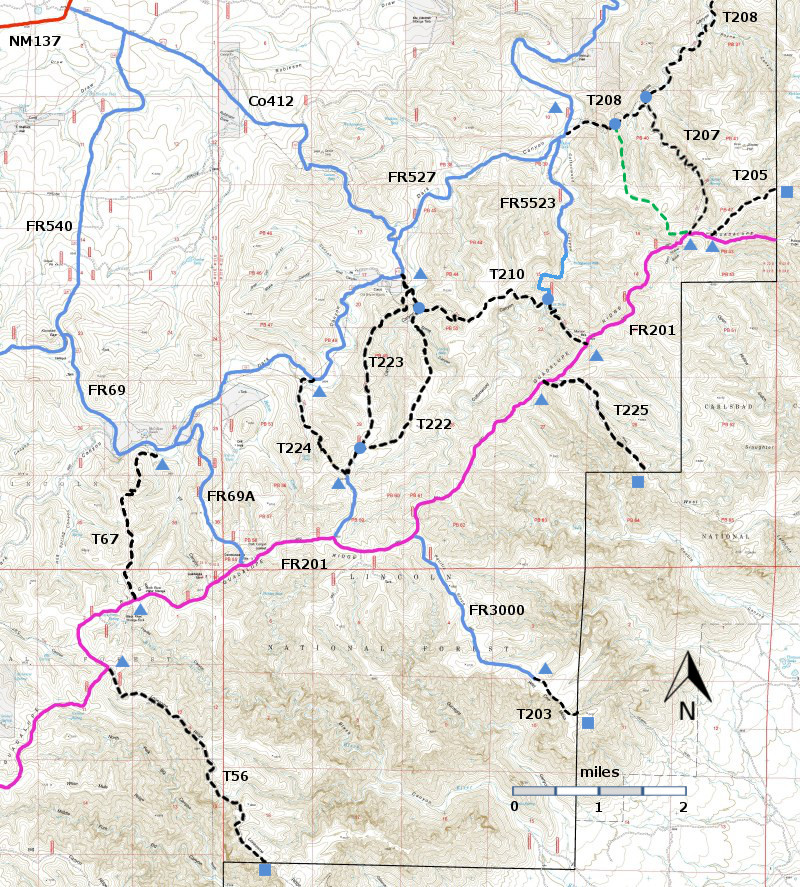
T225
Slaughter (Yucca Double) Trail


Guadalupe Ranger District
TL-green-190.jpg 
Download
T225
GPS Track
(as .GPX)
T56, T67, T203, T205, T207, T208, T210, T222, T223, T224, and T225 are shown as black dashed lines on the map.
FR201, shown in magenta, is considered to be impassable for most 4WD high clearance vehicles.

GuadalupeRD6mc-RTS-FR201-r18.jpg

LENGTH:
1.1 miles
ELEVATION:
6480 - 6720 ft
240 ft

difference
DIFFICULTY:
Moderate
SCENIC
RATING:
2
Contour Interval: 40 feet
Area Map (13 MB)

Gunsight Canyon Topo Map
Route Color Codespaved roads
(red)
FS roads, open
(blue)
FS roads, closed or impassable
(magenta)
main trail(s)
(black dashes)
---connector trail(s)
(green dashes)
---damaged or intermittent trail(s)
(orange over black dashes)
---closed trails(s)
(red over black dashes)
---
Symbolstrailhead
(blue triangle)
blue-triangle.jpgtrail junction
(blue dot)
blue-dot.jpgtrail end
(blue square)
blue-square.jpg

DESCRIPTION

 For this trail the scenic views are probably not worth the effort required to reach them unless you are on horseback. 

 ACCESS:

 To reach T225, take US285 northwest from Carlsbad (about 12 miles) to 0.6 mile beyond milepost 45 at its junction with NM137, Queen Highway. Turn left and follow the paved road 32 miles to milepost 20.  Continue along NM137 6.5 miles to the turnoff (left) for FR540 (which may also be signed as Klondike Gap Road).  FR540 is a very good gravel road.  Follow it 4.3 miles to its intersection with FR69.  Turn left and follow FR69 2.3 miles to its junction with FR69A.  Follow FR69A 2.3 miles to its junction with FR20, the nearest point of access for most high clearance 4WD vehicles.   The trailhead is 4.5 miles from the junction of FR69A and FR201.  FR201 is considered impassable form most high clearance 4WD vehicles T225 begins at FR201 and descends to the Forest boundary.  Access to the lower trail head is complex.
LOCATION(S) OF ACCESS POINT(S)
Lat/Lon hddd mm ss.sUTM/NAD83
TrailheadN32 06 28.0
W104 41 19.7
 13 S
529358
3552426
Trail End (Forest Boundary)N32 05 55.2
W104 40 35.3
13 S
530525
3551418

Last Hiked:  Not HikedWeb Page Updated:March 20, 2014
Copyright Lynn Melton 2014Contact: LNFTG14@gmail.com